
File:Map of Eagle County, Colorado.png
Original file (3,265 × 2,571 pixels, file size: 56 KB, MIME type: image/png)
| This is a file from the Wikimedia Commons. Information from its description page there is shown below. Commons is a freely licensed media file repository. You can help. |
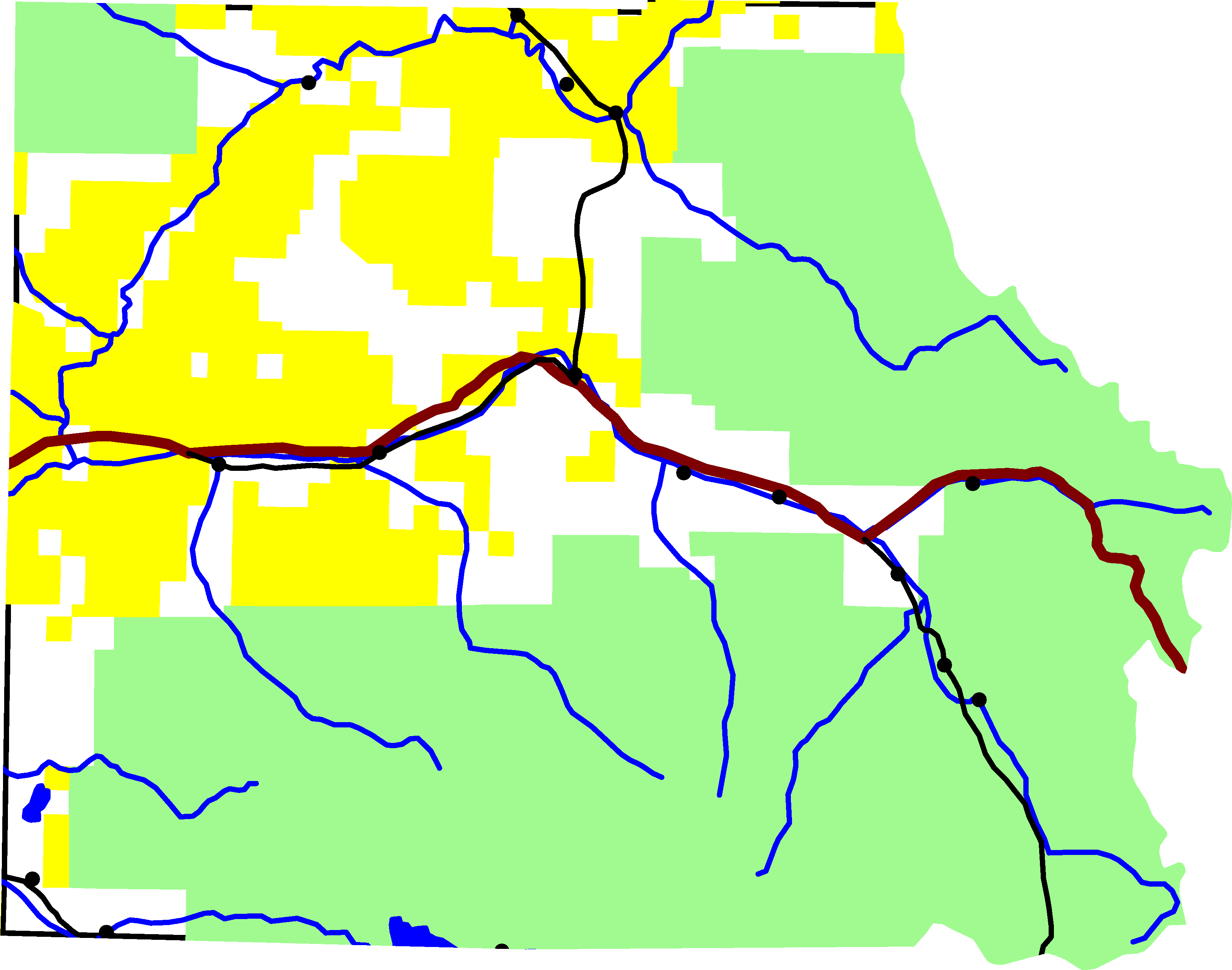
A map of Eagle County, Colorado. Green is White River National Forest, yellow is Bureau of Land Management land. The reddish line from east to west is Interstate 70. The black lines are roads. In the southeastern quadrant is U.S. Highway 24. In the north-central is Colorado State Highway 131. Running along I-70 is U.S. Highway 6. And in the south-west corner is Colorado State Highway 82.
For scale, the county is about 50 miles wide.
The lake on the southern border is Ruedi Reservior, with Fryingpan River. Gore Creek is the easternmost river on the map. It joins the Eagle River, which starts in the south-east corner of the county and flows north-west until it joins I-70. The river in the northern half of the county is the Colorado River.
David Benbennick made this map from data at nationalatlas.gov. The data is accurate to 0.000278 degrees, or about 65 feet.
| I, the copyright holder of this work, release this work into the public domain. This applies worldwide. In some countries this may not be legally possible; if so: I grant anyone the right to use this work for any purpose, without any conditions, unless such conditions are required by law. |
File history
Click on a date/time to view the file as it appeared at that time.
| Date/Time | Thumbnail | Dimensions | User | Comment | |
|---|---|---|---|---|---|
| current | 22:23, 6 August 2005 | | 3,265 × 2,571 (56 KB) | Dbenbenn | lighter green for national forest, #A0F090, taken from w:Wikipedia talk:WikiProject Maps |
| 16:01, 2 August 2005 |  | 3,265 × 2,571 (56 KB) | Dbenbenn | put county boundary underneath everything else. More accurate display at border. | |
| 16:15, 1 August 2005 |  | 3,265 × 2,571 (58 KB) | Dbenbenn | by me, PD |
File usage
Global file usage
The following other wikis use this file:
- Usage on es.wikipedia.org
- Usage on ja.wikipedia.org
- Usage on ro.wikipedia.org