
File:Map Mobile River tunnels area.gif
No higher resolution available.
Map_Mobile_River_tunnels_area.gif (680 × 560 pixels, file size: 51 KB, MIME type: image/gif)
| This is a file from the Wikimedia Commons. Information from its description page there is shown below. Commons is a freely licensed media file repository. You can help. |
Summary
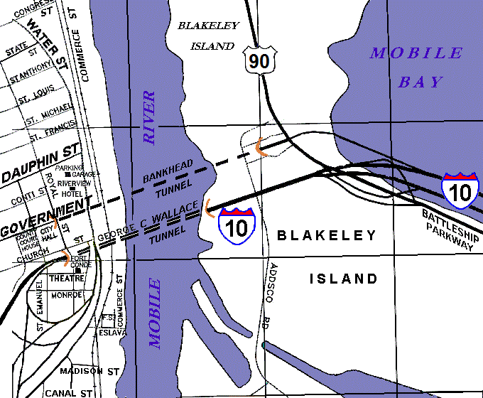
| Description | Rough diagram of central Mobile, Alabama, along the Mobile River, showing locations of the Bankhead Tunnel and the George C. Wallace Tunnel connecting Blakeley Island to downtown Mobile. The whole area is within the Mobile city limits which begin further east, just beyond Battleship Memorial Park along the Jubilee Parkway. |
| Date | |
| Source | self-made (based on archives map) |
| Author | User:Wikid77 |
Licensing
| I, the copyright holder of this work, release this work into the public domain. This applies worldwide. In some countries this may not be legally possible; if so: I grant anyone the right to use this work for any purpose, without any conditions, unless such conditions are required by law. |
File history
Click on a date/time to view the file as it appeared at that time.
| Date/Time | Thumbnail | Dimensions | User | Comment | |
|---|---|---|---|---|---|
| current | 00:16, 23 August 2012 | | 680 × 560 (51 KB) | RBBrittain | Replace "ALT 90" shield text; northerly route to bridge is now regular US 90. |
| 19:36, 12 December 2007 |  | 680 × 560 (34 KB) | Wikid77 | initial upload |
File usage
The following pages on the English Wikipedia use this file (pages on other projects are not listed):
Global file usage
The following other wikis use this file:
- Usage on de.wikipedia.org
- Usage on www.wikidata.org