
File:Map France 1477-en sovereign Béarn.png

Size of this preview: 556 × 599 pixels. Other resolutions: 223 × 240 pixels | 445 × 480 pixels | 900 × 970 pixels.
Original file (900 × 970 pixels, file size: 608 KB, MIME type: image/png)
| This is a file from the Wikimedia Commons. Information from its description page there is shown below. Commons is a freely licensed media file repository. You can help. |
Summary
| Description |
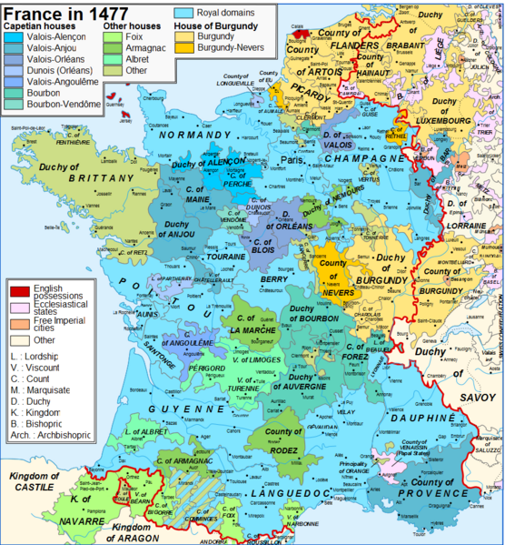
English: Conspicuous inaccuracy: Béarn did not pay homage to the French crown, it was a sovereign principality |
| Date | |
| Source | Own work |
| Author | Iñaki LLM |
Licensing
I, the copyright holder of this work, hereby publish it under the following license:
This file is licensed under the Creative Commons Attribution-Share Alike 3.0 Unported license.
- You are free:
- to share – to copy, distribute and transmit the work
- to remix – to adapt the work
- Under the following conditions:
- attribution – You must give appropriate credit, provide a link to the license, and indicate if changes were made. You may do so in any reasonable manner, but not in any way that suggests the licensor endorses you or your use.
- share alike – If you remix, transform, or build upon the material, you must distribute your contributions under the same or compatible license as the original.
File history
Click on a date/time to view the file as it appeared at that time.
| Date/Time | Thumbnail | Dimensions | User | Comment | |
|---|---|---|---|---|---|
| current | 18:20, 7 April 2024 | | 900 × 970 (608 KB) | Jouvencel | First map was correct. Brittany was in the kingdom but not the royal domain. |
| 22:49, 31 January 2019 |  | 900 × 970 (602 KB) | Iñaki LL | Brittany not in the Kingdom of France | |
| 20:27, 9 June 2014 |  | 900 × 970 (608 KB) | Iñaki LLM | User created page with UploadWizard |
File usage
The following pages on the English Wikipedia use this file (pages on other projects are not listed):
Global file usage
The following other wikis use this file:
- Usage on azb.wikipedia.org
- Usage on el.wikipedia.org
- Usage on eu.wikipedia.org
- Usage on fr.wikipedia.org
- Usage on he.wikipedia.org
- Usage on it.wikipedia.org