
File:Map-of-southeast-asia 1300 CE.png
Size of this preview: 426 × 599 pixels. Other resolutions: 171 × 240 pixels | 341 × 480 pixels.
Original file (800 × 1,125 pixels, file size: 251 KB, MIME type: image/png)
| This is a file from the Wikimedia Commons. Information from its description page there is shown below. Commons is a freely licensed media file repository. You can help. |

|
This historical map image could be re-created using vector graphics as an SVG file. This has several advantages; see Commons:Media for cleanup for more information. If an SVG form of this image is available, please upload it and afterwards replace this template with
{{vector version available|new image name}}.
It is recommended to name the SVG file “Map-of-southeast-asia 1300 CE.svg”—then the template Vector version available (or Vva) does not need the new image name parameter. |
Summary
| Description |
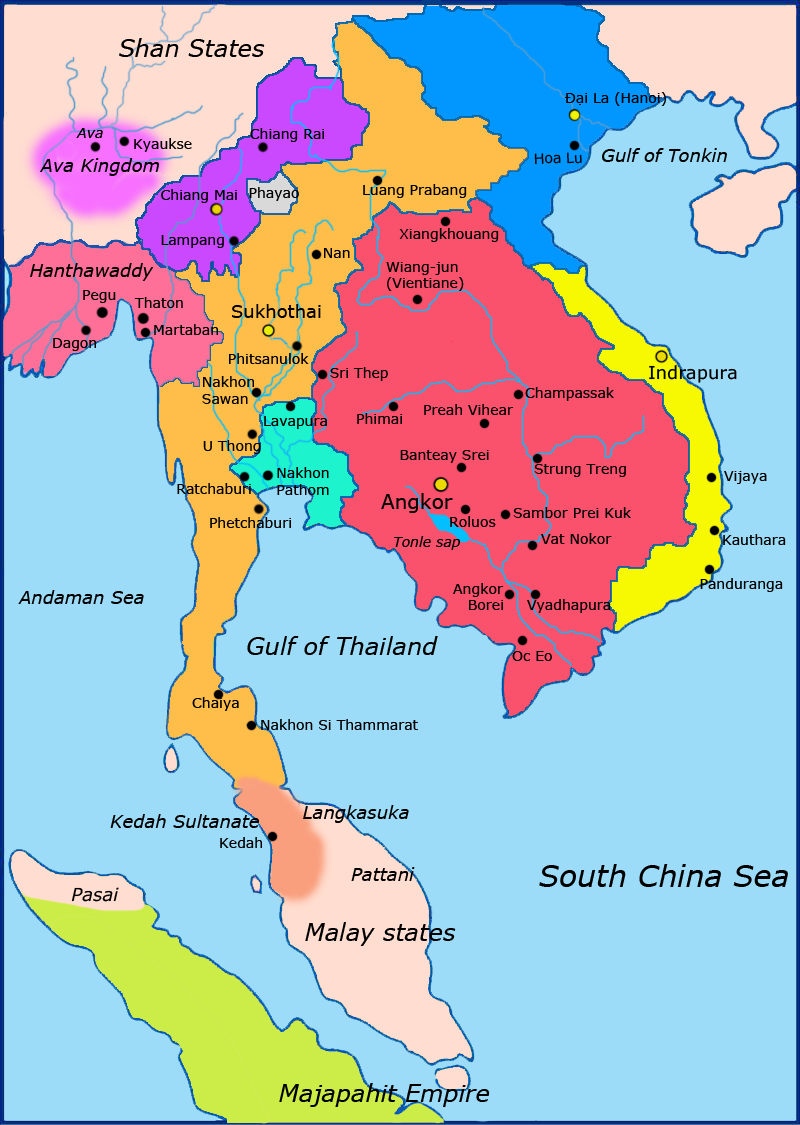
English: Map of Southeast Asia circa 1300 CE, showing Khmer Empire in red, Lavo kingdom/Dvaravati in light blue, Sukhothai empire in orange, Champa in yellow, Dai Viet in blue, Kingdom of Lanna in purple and surrounding states. |
| Date | |
| Source |
http://ecaimaps.berkeley.edu/animations/2003_03_khmer_animation.swf http://www.britannica.com/EBchecked/media/3395/Khmer-empire-1200 Atlas of world history, Patrick Karl O'brien. Societies, Networks, and Transitions: A Global History, Volume B. Craig A.Lockard http://upload.wikimedia.org/wikipedia/commons/thumb/4/45/Srivijaya_Empire.svg/2000px-Srivijaya_Empire.svg.png File:DvaravatiMapThailand.png http://upload.wikimedia.org/wikipedia/commons/e/eb/Thailand_2002_CIA_map.jpg |
| Author | Javierfv1212 |
| Other versions |

Licensing
I, the copyright holder of this work, hereby publish it under the following license:
| This file is made available under the Creative Commons CC0 1.0 Universal Public Domain Dedication. | |
| The person who associated a work with this deed has dedicated the work to the public domain by waiving all of their rights to the work worldwide under copyright law, including all related and neighboring rights, to the extent allowed by law. You can copy, modify, distribute and perform the work, even for commercial purposes, all without asking permission.
|
File history
Click on a date/time to view the file as it appeared at that time.
| Date/Time | Thumbnail | Dimensions | User | Comment | |
|---|---|---|---|---|---|
| current | 02:23, 28 March 2011 | | 800 × 1,125 (251 KB) | Javierfv1212 | {{Information |Description ={{en|1=Map of Southeast Asia circa 1300 CE, showing Khmer Empire in red, Lavo kingdom/Dvaravati in light blue, Sukhothai empire in orange, Champa in yellow, Kingdom of Lanna in purple and surrounding states. sources http: |
File usage
No pages on the English Wikipedia use this file (pages on other projects are not listed).
Global file usage
The following other wikis use this file:
- Usage on ar.wikipedia.org
- Usage on ast.wikipedia.org
- Usage on es.wikipedia.org
- Usage on fi.wikipedia.org
- Usage on fr.wikipedia.org
- Usage on id.wikipedia.org
- Usage on is.wikipedia.org
- Usage on it.wikipedia.org
- Usage on ja.wikipedia.org
- Usage on ka.wikipedia.org
- Usage on km.wikipedia.org
- Usage on ko.wikipedia.org
- Usage on lo.wikipedia.org
- Usage on ms.wikipedia.org
- Usage on my.wikipedia.org
- Usage on nl.wikipedia.org
- Usage on no.wikipedia.org
- Usage on pt.wikipedia.org
- Usage on sa.wikipedia.org
- Usage on ta.wikipedia.org
- Usage on th.wikipedia.org
- Usage on tr.wikipedia.org
- Usage on uk.wikipedia.org
- Usage on www.wikidata.org