
File:MENA.svg

Size of this PNG preview of this SVG file: 800 × 485 pixels. Other resolutions: 320 × 194 pixels | 640 × 388 pixels | 1,024 × 621 pixels | 1,280 × 776 pixels | 2,560 × 1,551 pixels | 802 × 486 pixels.
Original file (SVG file, nominally 802 × 486 pixels, file size: 363 KB)
| This is a file from the Wikimedia Commons. Information from its description page there is shown below. Commons is a freely licensed media file repository. You can help. |
Summary
| Description |
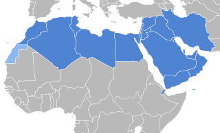
English: Countries of the MENA region according to the definition of the World Bank.
Deutsch: Staaten der MENA-Region nach Definition der Weltbank.
Français : Pays de la région MENA selon la définition de la Banque mondiale.
العربية: دول منطقة الشرق الأوسط وشمال أفريقيا وفقًا لتعريف البنك الدولي. |
||
| Date | |||
| Source |
This file was derived from: Arab World Green.svg by T.seppelt
|
||
| Author | Furfur | ||
| Permission (Reusing this file) |
I, the copyright holder of this work, hereby publish it under the following licenses:
This file is licensed under the Creative Commons Attribution-Share Alike 4.0 International license.
You may select the license of your choice. |
||
| Other versions |
|
||
| SVG development | This map was created with Adobe Illustrator. |


.png)
File history
Click on a date/time to view the file as it appeared at that time.
| Date/Time | Thumbnail | Dimensions | User | Comment | |
|---|---|---|---|---|---|
| current | 19:51, 16 January 2021 | | 802 × 486 (363 KB) | Nederlandse Leeuw | The source provided was a dead link. According to the 2003 World Bank study by Dipak Dasgupta & Mustapha, page 21, the World Bank geographic classification of MENA is 'Bahrain, Kuwait, Oman, Qatar, Saudi Arabia, and United Arab Emirates, (...) Algeria, Djibouti, the Arab Republic of Egypt, Iraq, the Islamic Republic of Iran, Israel, Jordan, Lebanon, Libya, Malta, Morocco, the Republic of Yemen, the Syrian Arab Republic, Tunisia, and West Bank and Gaza.' This is confirmed on the current World... |
| 23:01, 12 September 2020 |  | 802 × 486 (362 KB) | Furfur | Korrektur | |
| 22:53, 12 September 2020 |  | 802 × 486 (321 KB) | Furfur | == {{int:filedesc}} == {{Information |Description={{User:Medium69/Traduction}} {{en|1=Countries of the MENA region according to the definition of the World Bank.}} {{de|1=Staaten der MENA-Region nach Definition der Weltbank.}} |Source={{Derived from|Arab World Green.svg|user=T.seppelt}} *[http://web.worldbank.org/WBSITE/EXTERNAL/COUNTRIES/MENAEXT/0,,menuPK:247619~pagePK:146748~piPK:146812~theSitePK:256299,00.html MENA Countries], World Bank |Date=2020-09-13 |Author={{U|Furfur}} |Permission={{... |
File usage
The following pages on the English Wikipedia use this file (pages on other projects are not listed):
Global file usage
The following other wikis use this file:
- Usage on cs.wikipedia.org
- Usage on de.wikipedia.org
- Usage on he.wikipedia.org
- Usage on ku.wikipedia.org