
File:Location map of Hudson County, New Jersey.svg

Size of this PNG preview of this SVG file: 700 × 600 pixels. Other resolutions: 280 × 240 pixels | 560 × 480 pixels | 896 × 768 pixels | 1,195 × 1,024 pixels | 2,389 × 2,048 pixels.
Original file (SVG file, nominally 896 × 768 pixels, file size: 534 KB)
| This is a file from the Wikimedia Commons. Information from its description page there is shown below. Commons is a freely licensed media file repository. You can help. |
Summary
| Description |
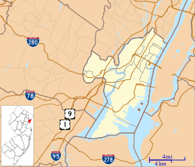
English: This is a map of Hudson County, New Jersey, USA which includes incorporated settlements, township borders, and major highways. |
| Date | |
| Source | My own work, using custom-written MapScript applications with United States Census Bureau data |
| Author | Omnedon |
Licensing
| I, the copyright holder of this work, release this work into the public domain. This applies worldwide. In some countries this may not be legally possible; if so: I grant anyone the right to use this work for any purpose, without any conditions, unless such conditions are required by law. |
File history
Click on a date/time to view the file as it appeared at that time.
| Date/Time | Thumbnail | Dimensions | User | Comment | |
|---|---|---|---|---|---|
| current | 14:10, 4 October 2012 | | 896 × 768 (534 KB) | Omnedon | == {{int:filedesc}} == {{Information |Description={{en|This is a map of Hudson County, New Jersey, USA which includes incorporated settlements, township borders, and major highways.}} |Source=My own work, using custom-w... |
File usage
More than 100 pages use this file. The following list shows the first 100 pages that use this file only. A full list is available.
- 2016 Hoboken train crash
- 2019 Jersey City shooting
- 99 Hudson Street
- Arlington, New Jersey
- Association of Exempt Firemen Building
- Babbitt, North Bergen
- Barrow Mansion
- Bayonne, New Jersey
- Bayonne Community Museum
- Bayonne Truck House No. 1
- Bergen Point
- Bergen Section, Jersey City
- Bergen Tunnels
- Berry Lane Park
- Buildings at 1200–1206 Washington Street
- Central Railroad of New Jersey Terminal
- Church of Our Lady of Grace (Hoboken, New Jersey)
- Church of the Holy Innocents (Hoboken, New Jersey)
- Clark Thread Company Historic District
- Collins Park (Bayonne, New Jersey)
- Communipaw
- Croxton, Jersey City
- Dock Bridge
- East Newark, New Jersey
- Edwin A. Stevens Hall
- Ellis Island
- Ellis Island Immigrant Hospital
- Engine Company No. 2
- Engine Company No. 3
- Engine Company No. 4
- Engine Company No. 5
- Engine Company No. 6
- Engine House No. 3, Truck No. 2
- Fairmount Apartments (Jersey City, New Jersey)
- Ficken's Warehouse
- Firemen's Monument (Hoboken, New Jersey)
- First Baptist Church (Hoboken, New Jersey)
- First Reformed Dutch Church of Bergen Neck
- Grace Church Van Vorst
- Great Atlantic and Pacific Tea Company Warehouse
- Greenville, Jersey City
- Guttenberg, New Jersey
- Hackensack Water Company Complex
- Hale-Whitney Mansion
- Hamilton Park, Jersey City
- Harrison, New Jersey
- Harsimus
- Headroom LGBTQ+ Lounge
- Highland Hose No. 4
- Hispanics and Latinos in New Jersey
- Hoboken, New Jersey
- Hoboken City Hall
- Hoboken Land and Improvement Company Building
- Hoboken Public Library
- Hoboken Terminal
- Hook and Ladder No. 3
- Hudson County Courthouse
- Hudson and Manhattan Railroad Powerhouse
- Jefferson Trust Company
- Jersey City Reservoir No. 3
- Jersey City Urby
- Jersey City YMCA
- Kearny, New Jersey
- Keuffel and Esser Manufacturing Complex
- Liberty Harbor
- Liberty Island
- Liberty Science Center
- Marion Section
- Monastery and Church of Saint Michael the Archangel
- New Durham, North Bergen
- Newark Bay
- North Bergen, New Jersey
- Old Bergen Church
- Our Lady of Mt. Carmel (Bayonne, New Jersey)
- Pohlmann's Hall
- Pulaski Skyway
- Racetrack Section, North Bergen
- Rutowski Park
- Saint Ann Roman Catholic Church and Rectory
- Secaucus, New Jersey
- Skyway Park
- St. Anthony of Padua Catholic Church
- St. Joseph Cathedral (Bayonne, New Jersey)
- St. Mark Coptic Orthodox Church (Jersey City, New Jersey)
- St. Patrick's Parish and Buildings
- St. Vincent de Paul Catholic Church (Bayonne, New Jersey)
- Statue of Liberty National Monument
- Temple Beth-El (Jersey City, New Jersey)
- The Beacon (Jersey City)
- The Lembeck and Betz Eagle Brewing Company
- Union City, New Jersey
- United Synagogue of Hoboken
- Van Vorst Park
- Van Wagenen House
- Weehawken, New Jersey
- Weehawken Cove
- West New York, New Jersey
- White Eagle Hall
- William Hall Walker Gymnasium
- William L. Dickinson High School
View more links to this file.
Global file usage
The following other wikis use this file:
- Usage on ar.wikipedia.org
- Usage on azb.wikipedia.org
- Usage on ceb.wikipedia.org
- Usage on fa.wikipedia.org
- Usage on fr.wikipedia.org
- Usage on he.wikipedia.org
- Usage on id.wikipedia.org
- Usage on kn.wikipedia.org
- Usage on ml.wikipedia.org
- Usage on simple.wikipedia.org
- Usage on si.wikipedia.org
- Usage on th.wikipedia.org
- Usage on tr.wikipedia.org
- Usage on war.wikipedia.org
- Usage on zh.wikipedia.org