
File:Location map United Kingdom City of Preston.svg

Size of this PNG preview of this SVG file: 545 × 599 pixels. Other resolutions: 218 × 240 pixels | 437 × 480 pixels | 699 × 768 pixels | 931 × 1,024 pixels | 1,863 × 2,048 pixels | 1,187 × 1,305 pixels.
Original file (SVG file, nominally 1,187 × 1,305 pixels, file size: 4.27 MB)
| This is a file from the Wikimedia Commons. Information from its description page there is shown below. Commons is a freely licensed media file repository. You can help. |
Summary
| Description |
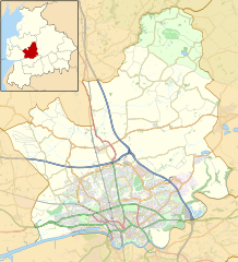
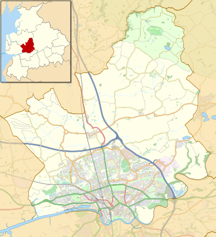
English: Map of the City of Preston district, Lancashire, England
Part of the Forest of Bowland Area of Outstanding Natural Beauty
Equirectangular map projection on WGS 84 datum, with N/S stretched 165% Geographic limits:
|
| Date | Original version 2014-07-22 22:19 (UTC), updated 2018-04-07. |
| Source |
This file was derived from: |
| Author |
|

.svg)
Licensing
| This work contains information from OpenStreetMap, which is made available under the Open Database License (ODbL).
The ODbL does not require any particular license for maps produced from ODbL data. Prior to 1 August 2020, map tiles produced by the OpenStreetMap Foundation were licensed under the CC-BY-SA-2.0 license. Maps produced by other people may be subject to other licences. |
This file is licensed under the Creative Commons Attribution-Share Alike 2.0 Generic license.
Attribution: © OpenStreetMap contributors. © Natural England copyright 2012. Contains Ordnance Survey data © Crown copyright and database right 2012.
- You are free:
- to share – to copy, distribute and transmit the work
- to remix – to adapt the work
- Under the following conditions:
- attribution – You must give appropriate credit, provide a link to the license, and indicate if changes were made. You may do so in any reasonable manner, but not in any way that suggests the licensor endorses you or your use.
- share alike – If you remix, transform, or build upon the material, you must distribute your contributions under the same or compatible license as the original.
Original upload log
This image is a derivative work of the following images:
- File:Preston_UK_ward_map_2010_(blank).svg licensed with Cc-by-sa-3.0
- 2011-04-24T22:48:11Z Nilfanion 1187x1305 (329725 Bytes) {{Information |Description=Map of Preston, Lancashire, UK with electoral wards shown. Equirectangular map projection on WGS 84 datum, with N/S stretched 165% Geographic limits: *West: 2.83W *East: 2.59W *North: 53.90N *Sout
Uploaded with derivativeFX
File history
Click on a date/time to view the file as it appeared at that time.
| Date/Time | Thumbnail | Dimensions | User | Comment | |
|---|---|---|---|---|---|
| current | 19:04, 7 April 2018 | | 1,187 × 1,305 (4.27 MB) | Dr Greg | Added Broughton bypass; adjusted some road colours for clarity |
| 21:29, 22 July 2014 |  | 1,187 × 1,305 (8.33 MB) | Dr Greg | Add Forest of Bowland; remove some unnecessary details | |
| 21:01, 15 February 2013 |  | 1,187 × 1,305 (8.77 MB) | Dr Greg | == {{int:filedesc}} == {{Information |Description= {{en|Map of Preston, Lancashire, UK with electoral wards shown. Equirectangular map projection on WGS 84 datum, with N/S stretched 165% Geographic limits: *West: 2.83W *East: 2.59W *North: 53.... |
File usage
The following pages on the English Wikipedia use this file (pages on other projects are not listed):
- Barton, Preston
- Barton and Broughton railway station
- Beacon Fell, Lancashire
- Broughton, Lancashire
- Broughton railway station (England)
- Catforth
- Chingle Hall
- City of Preston, Lancashire
- Eaves, Lancashire
- Fulwood, Lancashire
- Goosnargh
- Grimsargh
- Grimsargh railway station
- HM Prison Preston
- Haighton
- Inglewhite
- Ingol
- Lea, Lancashire
- Preston, Lancashire
- RAF Barton Hall
- St Anne's Church, Woodplumpton
- St John the Baptist's Church, Broughton
- St Lawrence's Church, Barton
- St Mary's Church, Fernyhalgh
- St Mary's Church, Goosnargh
- St Michael's Church, Grimsargh
- The Green Man at Inglewhite
- The Plough at Eaves
- Transport in Preston
- Whitechapel, Lancashire
- Whittingham, Lancashire
- Whittingham Hospital
- Woodplumpton
- Ye Horns Inn
- Talk:City of Preston, Lancashire
- User:Dr Greg/Sandpit3
- Module:Location map/data/United Kingdom City of Preston
- Module:Location map/data/United Kingdom City of Preston/doc
Global file usage
The following other wikis use this file:
- Usage on ar.wikipedia.org
- Usage on azb.wikipedia.org
- Usage on ceb.wikipedia.org
- Usage on fa.wikipedia.org
- Usage on ja.wikipedia.org
- Usage on kn.wikipedia.org
- Usage on si.wikipedia.org
- Usage on tr.wikipedia.org
- Usage on war.wikipedia.org