
File:Location-Kornwerderzand.png
No higher resolution available.
Location-Kornwerderzand.png (280 × 130 pixels, file size: 7 KB, MIME type: image/png)
| This is a file from the Wikimedia Commons. Information from its description page there is shown below. Commons is a freely licensed media file repository. You can help. |
| Description |
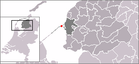
Nederlands: Kaart met de locatie van Kornwerderzand, gemaakt uit sjabloon van Wikipedia-gebruiker Mtcv
Deutsch: Kate mit der Position von Kornwerderzand
English: Map with Position of Kornwerderzand |
||
| Source |
History@ Netherland Wiki: Upload 3 dec 2004 18:23 . . Nikio (6937 bytes) (This Version) |
||
| Author | Created and uploaded as PD by Nikio based on a PD template by Mtcv | ||
| Permission (Reusing this file) |
|
This Image is Used in
- German Wikipedia Image Description Page
- Netherland Wikipedia Image Description Page
- French Wikipedia Image Description Page
- Frisian Wikipedia Image Description Page
- please edit and complete this listing
File history
Click on a date/time to view the file as it appeared at that time.
| Date/Time | Thumbnail | Dimensions | User | Comment | |
|---|---|---|---|---|---|
| current | 13:06, 3 August 2005 | | 280 × 130 (7 KB) | Stefan-Xp | {{nl|Kaart met de locatie van Kornwerderzand, gemaakt uit sjabloon van Wikipedia-gebruiker Mtcv}} {{de|Kate mit der Position von Kornwerderzand}} {{en}} Map with Postition of Kornwerderzand History@ Netherland Wiki: Upload 3 dec 2004 18:23 . . Nikio (69 |
File usage
The following pages on the English Wikipedia use this file (pages on other projects are not listed):
Global file usage
The following other wikis use this file:
- Usage on de.wikipedia.org
- Usage on fa.wikipedia.org
- Usage on fr.wikipedia.org
- Usage on fy.wikipedia.org
- Usage on www.wikidata.org