
File:Ladram Bay, west of Sidmouth - geograph.org.uk - 71739.jpg
No higher resolution available.
Ladram_Bay,_west_of_Sidmouth_-_geograph.org.uk_-_71739.jpg (640 × 444 pixels, file size: 78 KB, MIME type: image/jpeg)
| This is a file from the Wikimedia Commons. Information from its description page there is shown below. Commons is a freely licensed media file repository. You can help. |
Summary
| Description |
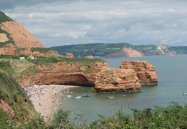
English: Ladram Bay, west of Sidmouth. This very sheltered little cove beneath the red sandstone cliffs and High Peak Hill is most obviously a popular summer bathing spot. In the distance, beyond Sidmouth can be seen the red cliff face of Salcombe Hill and beyond that, Dunscombe Cliff. |
| Date | |
| Source | From geograph.org.uk |
| Author | Tony Atkin |
| Attribution (required by the license) | Tony Atkin / Ladram Bay, west of Sidmouth / |
| Camera location | | View this and other nearby images on: OpenStreetMap |
|---|
_heading:45.00&language=en)
| Object location | | View this and other nearby images on: OpenStreetMap |
|---|
_heading:45.00&language=en)
Licensing

|
This image was taken from the Geograph project collection. See this photograph's page on the Geograph website for the photographer's contact details. The copyright on this image is owned by Tony Atkin and is licensed for reuse under the Creative Commons Attribution-ShareAlike 2.0 license.
|
This file is licensed under the Creative Commons Attribution-Share Alike 2.0 Generic license.
Attribution: Tony Atkin
- You are free:
- to share – to copy, distribute and transmit the work
- to remix – to adapt the work
- Under the following conditions:
- attribution – You must give appropriate credit, provide a link to the license, and indicate if changes were made. You may do so in any reasonable manner, but not in any way that suggests the licensor endorses you or your use.
- share alike – If you remix, transform, or build upon the material, you must distribute your contributions under the same or compatible license as the original.
File history
Click on a date/time to view the file as it appeared at that time.
| Date/Time | Thumbnail | Dimensions | User | Comment | |
|---|---|---|---|---|---|
| current | 16:36, 30 January 2010 | | 640 × 444 (78 KB) | GeographBot | == {{int:filedesc}} == {{Information |description={{en|1=Ladram Bay, west of Sidmouth. This very sheltered little cove beneath the red sandstone cliffs and High Peak Hill is most obviously a popular summer bathing spot. In the distance, beyond Sidmouth c |
File usage
The following pages on the English Wikipedia use this file (pages on other projects are not listed):