
File:LDS Temples World Map.svg

Size of this PNG preview of this SVG file: 800 × 354 pixels. Other resolutions: 320 × 142 pixels | 640 × 284 pixels | 1,024 × 454 pixels | 1,280 × 567 pixels | 2,560 × 1,134 pixels.
Original file (SVG file, nominally 2,560 × 1,134 pixels, file size: 1.03 MB)
| This is a file from the Wikimedia Commons. Information from its description page there is shown below. Commons is a freely licensed media file repository. You can help. |
| Description |
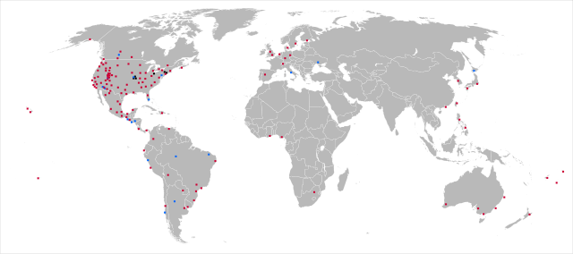
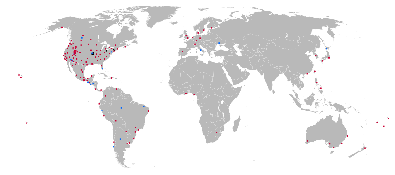
Map indicating the location of temples of The Church of Jesus Christ of Latter-day Saints: Operating temple
Temple planned or under construction
Former temple or proposed site for a planned temple where efforts have been suspended
Accurate to 24 June 2010. Based upon previous version by Snocrates. |
| Date | (UTC) |
| Source | |
| Author |
|
| Other versions |
Derivative works of this file: |
| This is a retouched picture, which means that it has been digitally altered from its original version. The original can be viewed here: LDS Temples World Map 200804.png:
|
| I, the copyright holder of this work, release this work into the public domain. This applies worldwide. In some countries this may not be legally possible; if so: I grant anyone the right to use this work for any purpose, without any conditions, unless such conditions are required by law. |
Original upload log
This image is a derivative work of the following images:
- Image:LDS_Temples_World_Map_200804.png licensed with PD-self
- 2008-04-28T17:16:07Z Arkyan 1427x628 (63314 Bytes)
- 2008-04-28T17:14:18Z Arkyan 1856x1275 (86136 Bytes) {{Information |Description=Map indicating the location of temples of the LDS Church. Red indicates an operating temple. Blue indicates a temple planned or under construction. Black indicates a temple formerly owned by the chu
Uploaded with derivativeFX
File history
Click on a date/time to view the file as it appeared at that time.
| Date/Time | Thumbnail | Dimensions | User | Comment | |
|---|---|---|---|---|---|
| current | 21:20, 26 February 2018 | | 2,560 × 1,134 (1.03 MB) | Lokal Profil | Changed basemap to File:BlankMap-World6,_compact.svg to e.g. get South Sudan border |
| 15:49, 24 June 2010 |  | 881 × 389 (1.69 MB) | Jaksmata | Added a blue dot for Payson, changed dots from blue to red for Vancouver, The Gila Valley, and Cebu. | |
| 15:15, 5 October 2009 |  | 881 × 389 (1.69 MB) | Jaksmata | Added Brigham City Utah, Concepción Chile, Fort Lauderdale Florida, Fortaleza Brazil, Sapporo Japan, and Halifax Nova Scotia (which was missing in prior versions). | |
| 09:54, 16 May 2009 |  | 881 × 389 (1.43 MB) | Trödel | Changed Draper Temple to Blue (completed), Added Trujillo Peru Temple | |
| 03:11, 16 May 2009 |  | 881 × 389 (1.43 MB) | Trödel | Changed Draper Temple to Blue (completed), Added Trujillo Peru Temple | |
| 18:01, 17 October 2008 |  | 940 × 415 (1.56 MB) | Shereth | Updated version | |
| 15:01, 6 June 2008 |  | 940 × 415 (1.56 MB) | Shereth | {{Information |Description= |Source= |Date= |Author= |Permission= |other_versions= }} | |
| 23:56, 5 June 2008 |  | 940 × 415 (1.56 MB) | Shereth | {{Information |Description= |Source= |Date= |Author= |Permission= |other_versions= }} | |
| 23:50, 5 June 2008 |  | 940 × 415 (1.56 MB) | Shereth | {{Information |Description=Map indicating the location of temples of the LDS Church. Red indicates an operating temple. Blue indicates a temple planned or under construction. Black indicates a temple formerly owned by the church or a planned temple where |
File usage
The following pages on the English Wikipedia use this file (pages on other projects are not listed):
Global file usage
The following other wikis use this file:
- Usage on ast.wikipedia.org
- Usage on es.wikipedia.org
- Usage on pt.wikipedia.org