
File:Kingdom of Algarve WDL471.png

Size of this preview: 800 × 577 pixels. Other resolutions: 320 × 231 pixels | 640 × 462 pixels | 1,024 × 738 pixels | 1,280 × 923 pixels | 1,420 × 1,024 pixels.
Original file (1,420 × 1,024 pixels, file size: 2.92 MB, MIME type: image/png)
| This is a file from the Wikimedia Commons. Information from its description page there is shown below. Commons is a freely licensed media file repository. You can help. |
Summary
| Author |
Русский: Лоран
Français : Laurent
English: Laurent
中文:劳伦斯
Português: Laurent
العربية: لورانت
Español: Laurent |
| Title |
Русский: Королевство Алгарве
Français : Royaume d'Algarve
English: Kingdom of Algarve
中文:阿尔加维王国
Português: Reino do Algarve
العربية: مملكة ألغارفة
Español: Reino de Algarve |
| Description |
Русский: На этой карте XVIII века, которая, очевидно, является перепечаткой с французского атласа начала XIX века, изображено Королевство Альгарве. В 1249 году португальский король Альфонсо III отвоевал у мавров южную часть Португалии. С тех пор король Альфонсо стал называться титулом Король Португалии и Альгарвы. Альгарве, соответствующий современной области Фаро, сохранял полуавтономный статус под португальским владычеством до 1910 года, когда он был включен в состав вновь провозглашенной Республики Португалия. Альгарве известен тем, что в XV веке из Сагреша на исследования Атлантики отправился принц Генри Мореплаватель. Слово "Альгарве" происходит от арабского "el-Garbh", что означает Запад.
Алгарве (Португалия) Français : Cette carte du 18ème siècle, est probablement une réimpression d'un des premiers Atlas du 19ème siècle, montrant le Royaume de l'Algarve. En 1249, le roi Alphonse III de Portugal acheva la reconquête du sud du Portugal sur les Maures. Par la suite, Alfonso pris le titre de Roi du Portugal et d'Algarve. L'Algarve, qui correspond à l'actuelle région du Faro, conserva une existence semi-autonome sous domination portugaise jusqu'en 1910, date à laquelle elle fut fusionnée avec la République du Portugal nouvellement proclamée. L'Algarve était connu comme l'endroit à partir duquel, à Sagres, le prince du 15ème siècle, Henri le Navigateur, lança des expéditions dans l'Atlantique. Le mot Algarve vient de l'arabe el-Garbh, qui signifie «l'Occident».
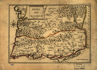
Algarve (Portugal) English: This 18th-century map, most likely a reprint from an early-19th century French atlas, shows the Kingdom of the Algarve. In 1249, King Alfonso III of Portugal completed the reconquest of southern Portugal from the Moors. Thereafter, Alfonso took to calling himself the King of Portugal and the Algarves. The Algarve, which corresponds to the present-day region of Faro, retained a semi-autonomous existence under Portuguese rule until 1910, when it was merged into the newly proclaimed Republic of Portugal. The Algarve was famous as the location from which, in Sagres, the 15th-century prince, Henry the Navigator, launched his voyages of discovery into the Atlantic. The word Algarve comes from the Arabic el-Garbh, meaning “the West.”
Algarve (Portugal) 中文:该 18 世纪的地图,貌似 19 世纪早期法国地图册中的一个翻版, 描述了阿尔加维王国。 1249 年,葡萄牙国王阿方索三世从摩尔人手中重新夺回了葡萄牙南部地区。 此后,阿方索自称为葡萄牙与阿尔加维国王。 阿尔加维,即今法鲁地区,在 1910 年与新宣布的葡萄牙共和国合并之前,仍然受葡萄牙统治,处于半独立状态。 阿尔加维十分出名,因为 15 世纪萨格里什亲王兼航海家亨利正是从阿尔加维开始了他的大西洋发现之旅。 阿尔加维一词来源于阿拉伯语 el-Garbh,意为“西部”。
阿尔加维(葡萄牙) Português: Este mapa do século XVIII é, muito provavelmente, uma reedição de um atlas francês, do início do século XIX, que mostra o Reino de Algarve. Em 1249, o rei Afonso III de Portugal concluía a reconquista do sul de Portugal dos mouros. Posteriormente, Alfonso auto-proclamou-se Rei de Portugal e dos Algarves. O Algarve, que corresponde atualmente à região de Faro, manteve uma existência semi-autonoma sob o domínio dos portugueses até 1910, quando foi incorporado à recém-proclamada República de Portugal. O Algarve ficou famoso como o local do qual partiram, de Sagres para o Atlântico, as viagens de descobertas de Henrique, o Navegador, príncipe do século XV. A palavra Algarve é oriunda do termo árabe el-Garbh, que significa "o Ocidente".
Algarve (Portugal) العربية: تظهر هذه الخريطة التي أعدت في القرن الثامن عشر والتي من المرجح أن تكونإعادة طباعة لأطلس فرنسي من أوائل القرن التاسع عشر مملكة الغرف. وكان ملك البرتغال ألفونسو الثالث قد أكمل استعادة جنوب البرتغال من المسلمين المغاربة في عام 1249. دعا ألفونسو نفسه بعد ذلك ملك البرتغال والغرف. ظلت الغرف، وهي ما يقابل منطقة فارو حاليًا، تتمتع بشبه حكم ذاتي في ظل الحكم البرتغالي حتى عام 1910، عندما تم دمجها مع جمهورية البرتغال التي أعلنت حديثًا. اشتهرت الغرف لأنها تضمنت ساغريس، وهو المكان الذي انطلق منه في القرن الخامس عشر الأمير هنري الملاح في رحلاته الاستكتشافية في المحيط الأطلسي. جاءت كلمة الغرف من الكلمة العربية الغرب.
ألغارفة (البرتغال) Español: Este mapa del siglo XVIII es muy probablemente una reedición de un atlas francés de principios del siglo XIX, y muestra el Reino de Algarve. En 1249, el rey Alfonso III de Portugal completó la reconquista del sur de Portugal, que estaba en posesión de los moros. Después, Alfonso se autoproclamó rey de Portugal y las Algarves. El Algarve, que se corresponde con la actual región de Faro, mantuvo una semi-autonomía bajo el dominio portugués hasta 1910, cuando se unió a la recién proclamada República de Portugal. El Algarve era conocido como el lugar desde el cual, en Sagres, el príncipe del siglo XV, Enrique el Navegante, comenzó sus viajes de descubrimientos en el Atlántico. La palabra Algarve deriva de la palabra árabe el-Garbh, que significa «el oeste».
Algarve (Portugal) |
| Date | between 1730 and 1774 |
| Medium |
Русский: Карты
Français : Cartes
English: Maps
中文:地图
Português: Mapas
العربية: خرائط
Español: Mapas |
| Dimensions |
English: 1 map : color ; 17 x 24 centimeters |
| Collection |
Русский: Библиотека Конгресса
Français : Bibliothèque du Congrès
English: Library of Congress
中文:国会图书馆
Português: Biblioteca do Congresso
العربية: مكتبة الكونغرس
Español: Biblioteca del Congreso |
| Place of creation |
Русский: Португалия
Français : Portugal
English: Portugal
中文:葡萄牙
Português: Portugal
العربية: البرتغال
Español: Portugal |
| Notes | Original language title: Reino do Algarve |
| References | http://hdl.loc.gov/loc.wdl/dlc.471 |
| Source/Photographer |
|
Licensing
|
This is a faithful photographic reproduction of a two-dimensional, public domain work of art. The work of art itself is in the public domain for the following reason:
The official position taken by the Wikimedia Foundation is that "faithful reproductions of two-dimensional public domain works of art are public domain".
This photographic reproduction is therefore also considered to be in the public domain in the United States. In other jurisdictions, re-use of this content may be restricted; see Reuse of PD-Art photographs for details. | ||||
File history
Click on a date/time to view the file as it appeared at that time.
| Date/Time | Thumbnail | Dimensions | User | Comment | |
|---|---|---|---|---|---|
| current | 18:01, 11 March 2014 | | 1,420 × 1,024 (2.92 MB) | Fæ | =={{int:filedesc}}== {{Artwork |artist = |author ={{ru|1=Лоран}} {{fr|1=Laurent}} {{en|1=Laurent}} {{zh|1=劳伦斯}} {{pt|1=Laurent}} {{ar|1=لورانت}} {{es|1=Laurent}} |title ={{ru|1=Королевство Алгарве}} {{fr|1=Royaume d&... |
File usage
The following pages on the English Wikipedia use this file (pages on other projects are not listed):
Global file usage
The following other wikis use this file:
- Usage on ca.wikipedia.org
- Usage on it.wikipedia.org
- Usage on pt.wikipedia.org
- Usage on ru.wikipedia.org