
File:John Rocque's map of London and Westminster, 1746, all sheets.jpg

Original file (48,387 × 25,318 pixels, file size: 283.1 MB, MIME type: image/jpeg)
| This is a file from the Wikimedia Commons. Information from its description page there is shown below. Commons is a freely licensed media file repository. You can help. |
| This is a featured picture, which means that members of the community have identified it as one of the finest images on the English Wikipedia, adding significantly to its accompanying article. If you have a different image of similar quality, be sure to upload it using the proper free license tag, add it to a relevant article, and nominate it. |
| This image was selected as picture of the day on the English Wikipedia for May 2, 2024. |
Summary
| Warning | The original file is very high-resolution. It might not load properly or could cause your browser to freeze when opened at full size. |
|---|
| Description |
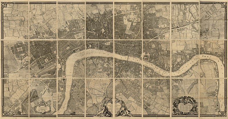
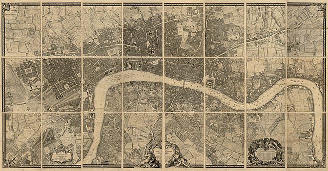
English: A plan of the cities of London and Westminster, and borough of Southwark, with the contiguous buildings
Map 203 x 385 cm. on 24 sheets 77 x 57 cm. Scale ca. 1:2,400. Relief shown by hachures and land form drawings. Includes drawings of ships on the Thames, lists of abbreviations and London aldermen's names, and a statement of dedication to the mayor and aldermen of London. Credit Line: Library of Congress, Geography and Map Division. |
| Date | |
| Source | Rocque, John, -1762, John Pine, and John Tinney. A plan of the cities of London and Westminster, and borough of Southwark, with the contiguous buildings. London, John Pine & John Tinney, 1746. Map. Cropped from https://www.loc.gov/item/76696823/ JPEG 2000 and converted to JPG |
| Author |
Rocque, John, -1762. Pine, John, 1690-1756. Tinney, John |
Licensing
|
This is a faithful photographic reproduction of a two-dimensional, public domain work of art. The work of art itself is in the public domain for the following reason:
The official position taken by the Wikimedia Foundation is that "faithful reproductions of two-dimensional public domain works of art are public domain".
This photographic reproduction is therefore also considered to be in the public domain in the United States. In other jurisdictions, re-use of this content may be restricted; see Reuse of PD-Art photographs for details. | ||||
File history
Click on a date/time to view the file as it appeared at that time.
| Date/Time | Thumbnail | Dimensions | User | Comment | |
|---|---|---|---|---|---|
| current | 04:49, 27 May 2019 | | 48,387 × 25,318 (283.1 MB) | Thincat | User created page with UploadWizard |
File usage
- John Rocque
- John Rocque's maps of London
- User:Bruxton
- User:Coffeeandcrumbs/sandbox/Main Page 2
- User:DrVerlucci/Main Page
- User:Holly Cheng/Main Page
- User:Mistman123/Testing/Main Page/Tomorrow
- User:NoSeptember/Main
- User:Vanak303/sandbox
- User:Voice of Clam/mainlinks
- User talk:MER-C/archives/63
- Wikipedia:Featured picture candidates/John Rocque's Map of London, Westminster, and Southwark
- Wikipedia:Featured picture candidates/November-2023
- Wikipedia:Featured pictures
- Wikipedia:Featured pictures/Diagrams, drawings, and maps/Maps
- Wikipedia:Featured pictures thumbs/78
- Wikipedia:Main Page/Day after tomorrow
- Wikipedia:Main Page/Tomorrow
- Wikipedia:Main Page (2016 redesign)/Tomorrow
- Wikipedia:Main Page alternatives/(Tomorrow and DYK Prep 1)
- Wikipedia:Main Page alternatives/(Tomorrow and DYK Prep 2)
- Wikipedia:Main Page alternatives/(Tomorrow and DYK Prep 3)
- Wikipedia:Main Page alternatives/(Tomorrow and DYK Prep 4)
- Wikipedia:Main Page alternatives/(Tomorrow and DYK Prep 5)
- Wikipedia:Main Page alternatives/(Tomorrow and DYK Prep 6)
- Wikipedia:Main Page alternatives/(Tomorrow and DYK Prep 7)
- Wikipedia:Main Page alternatives/(Tomorrow and Queue 1)
- Wikipedia:Main Page alternatives/(Tomorrow and Queue 1 DYK)
- Wikipedia:Main Page alternatives/(Tomorrow and Queue 2)
- Wikipedia:Main Page alternatives/(Tomorrow and Queue 3)
- Wikipedia:Main Page alternatives/(Tomorrow and Queue 4)
- Wikipedia:Main Page alternatives/(Tomorrow and Queue 5)
- Wikipedia:Main Page alternatives/(Tomorrow and Queue 6)
- Wikipedia:Main Page alternatives/(Tomorrow and Queue 7)
- Wikipedia:Main Page alternatives/(tomorrow+today)
- Wikipedia:Main Page queue
- Wikipedia:Picture of the day/May 2024
- Wikipedia:Picture of the day/On the main pages
- Wikipedia talk:Selected anniversaries/May 2
- Template:POTD/2024-05-02
- Template:POTD protected/2024-05-02