
File:Italy 1796 AD.png

Size of this preview: 419 × 600 pixels. Other resolutions: 167 × 240 pixels | 335 × 480 pixels | 1,007 × 1,442 pixels.
Original file (1,007 × 1,442 pixels, file size: 92 KB, MIME type: image/png)
| This is a file from the Wikimedia Commons. Information from its description page there is shown below. Commons is a freely licensed media file repository. You can help. |
Summary
| Description |
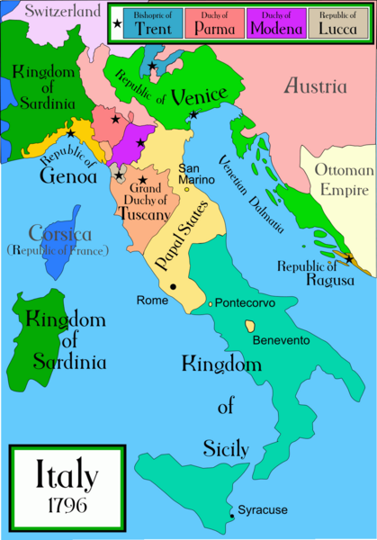
A political map of Italy in early 1796, before the Napoleonic wars, created by MapMaster.
|
||||||||
| Source | Own work | ||||||||
| Author | Capmo | ||||||||
| Permission (Reusing this file) |
I, the copyright holder of this work, hereby publish it under the following license:
|
||||||||
| Other versions |
[]
|


|
This historical map image could be re-created using vector graphics as an SVG file. This has several advantages; see Commons:Media for cleanup for more information. If an SVG form of this image is available, please upload it and afterwards replace this template with
{{vector version available|new image name}}.
It is recommended to name the SVG file “Italy 1796 AD.svg”—then the template Vector version available (or Vva) does not need the new image name parameter. |
File history
Click on a date/time to view the file as it appeared at that time.
| Date/Time | Thumbnail | Dimensions | User | Comment | |
|---|---|---|---|---|---|
| current | 01:26, 21 April 2009 | | 1,007 × 1,442 (92 KB) | Capmo | pallette reduction to 256 colours |
| 03:40, 16 April 2007 |  | 1,007 × 1,442 (324 KB) | MapMaster | slightly improved | |
| 03:25, 22 November 2006 |  | 629 × 901 (180 KB) | MapMaster | Slightly improved map: better color, location of capital cities, etc | |
| 04:29, 18 October 2006 |  | 1,266 × 1,814 (418 KB) | MapMaster | I uploaded a slightly improved map | |
| 03:55, 17 October 2006 |  | 1,267 × 1,821 (429 KB) | MapMaster | A political map of Italy in early 1796, before the Napoleonic wars, created by MapMaster. |
File usage
The following pages on the English Wikipedia use this file (pages on other projects are not listed):
Global file usage
The following other wikis use this file:
- Usage on ar.wikipedia.org
- Usage on ast.wikipedia.org
- Usage on azb.wikipedia.org
- Usage on br.wikipedia.org
- Usage on ca.wikipedia.org
- Usage on cs.wikipedia.org
- Usage on de.wikipedia.org
- Usage on es.wikipedia.org
- Usage on et.wikipedia.org
- Usage on eu.wikipedia.org
- Usage on fa.wikipedia.org
- Usage on fi.wikipedia.org
- Usage on fr.wikipedia.org
- Usage on gl.wikipedia.org
- Usage on he.wikipedia.org
- Usage on hi.wikipedia.org
- Usage on hr.wikipedia.org
- Usage on hy.wikipedia.org
- Usage on id.wikipedia.org
- Usage on is.wikipedia.org
- Usage on ja.wikipedia.org
- Usage on ka.wikipedia.org
- Usage on la.wikipedia.org
- Usage on li.wikipedia.org
- Usage on lt.wikipedia.org
- Usage on ms.wikipedia.org
- Usage on mwl.wikipedia.org
- Usage on nn.wikipedia.org
View more global usage of this file.