
File:IrishSeaReliefMap.jpg
Size of this preview: 415 × 600 pixels. Other resolutions: 166 × 240 pixels | 332 × 480 pixels | 531 × 768 pixels | 1,043 × 1,507 pixels.
Original file (1,043 × 1,507 pixels, file size: 2.15 MB, MIME type: image/jpeg)
| This is a file from the Wikimedia Commons. Information from its description page there is shown below. Commons is a freely licensed media file repository. You can help. |
Summary
| Description |
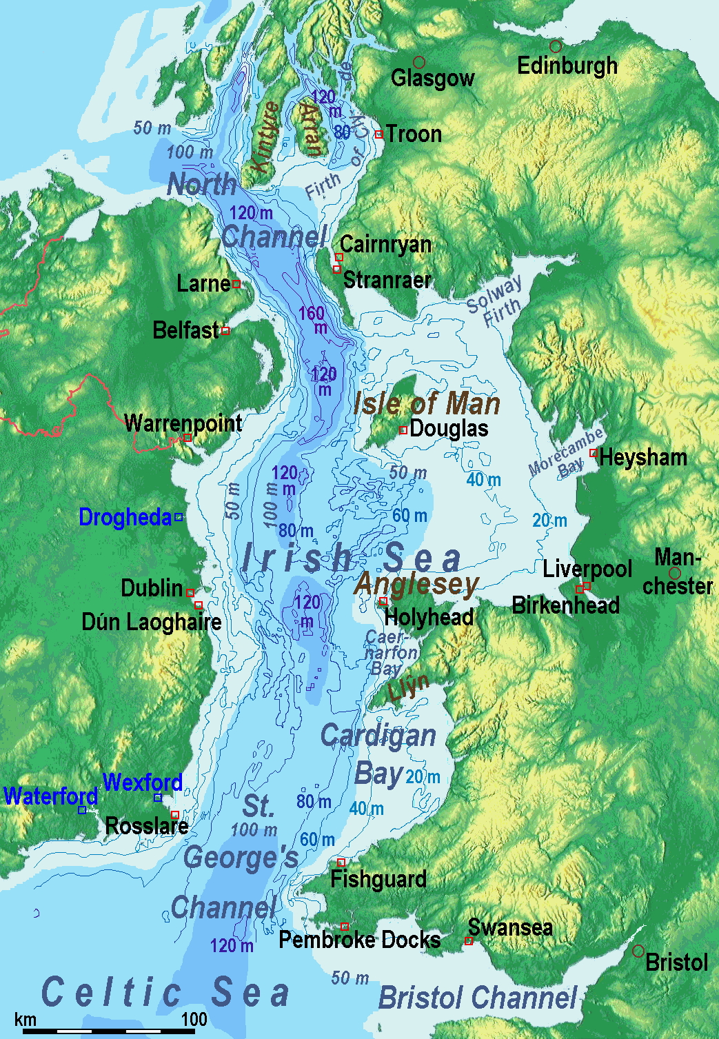
A map of the en:Irish Sea. Major ports shown with red marks. freight-only ports in blue. |
| Date | old map 2005-08-03; new map 2014-05-11 |
| Source | old map: http://www.vindaloo.uklinux.net/jjg/code/tmutils.html-> new map: Maps for Free and Own work |
| Author | old one Users SFC9394, Seabhcan on en.wikipedia, new one Ulamm (talk) 01:37, 11 May 2014 (UTC) |
| Permission (Reusing this file) |
old map: from http://www.vindaloo.uklinux.net/jjg/code/tmutils.html. Released to public domain by creator. |
| Other versions |
History of the od map
Old map riginally from en.wikipedia; description page is (was) here
- 14:22, 20 March 2006 SFC9394 461×561 (85,860 bytes) (Corrected locations for Cairnryan & Stranraer)
- 10:56, 25 November 2005 Seabhcan 461×561 (73,292 bytes) (Removed the ports of Heysham and Fleetwood, to which en:User:Robdurbar took offence. )
- 16:23, 3 August 2005 Seabhcan 461×561 (95,162 bytes) (Added channel names)
- 15:50, 3 August 2005 Seabhcan 461×561 (93,219 bytes) (A map of the en:Irish Sea Major ports shown in red. freight only ports in blue. from [1]. Released to public domain by creator.)
Sources of information for the new map
- internal report Nr. 174 of the National Oceanography Centre (Liverpool)
- http://www.dcenr.gov.ie (Department of Communications, Energy and Natural Resources) -> IOSEA4Annex–Master–r02–Fiinal.pdf (Fourth Strategic Environmental Assessment for Oil and Gas ACtivity in Irelands Offshore Waters) -> figures 2.1 & 2.2a
Licensing
I, the copyright holder of this work, hereby publish it under the following license:
This file is licensed under the Creative Commons Attribution-Share Alike 3.0 Unported license.
- You are free:
- to share – to copy, distribute and transmit the work
- to remix – to adapt the work
- Under the following conditions:
- attribution – You must give appropriate credit, provide a link to the license, and indicate if changes were made. You may do so in any reasonable manner, but not in any way that suggests the licensor endorses you or your use.
- share alike – If you remix, transform, or build upon the material, you must distribute your contributions under the same or compatible license as the original.
(Uploaded using CommonsHelper or PushForCommons)
File history
Click on a date/time to view the file as it appeared at that time.
| Date/Time | Thumbnail | Dimensions | User | Comment | |
|---|---|---|---|---|---|
| current | 11:42, 13 May 2014 | | 1,043 × 1,507 (2.15 MB) | Ulamm | optimized colour scale |
| 14:17, 12 May 2014 |  | 1,043 × 1,507 (1.87 MB) | Ulamm | more names, smaller letters | |
| 12:25, 11 May 2014 |  | 1,043 × 1,449 (1.73 MB) | Ulamm | depths and names of bays and inlets | |
| 10:56, 11 May 2014 |  | 1,043 × 1,449 (1.71 MB) | Ulamm | land colours lightened | |
| 02:22, 11 May 2014 |  | 1,043 × 1,449 (1.7 MB) | Ulamm | more ports | |
| 01:50, 11 May 2014 |  | 1,043 × 1,449 (1.69 MB) | Ulamm | completion outside the Irish Sea | |
| 01:39, 11 May 2014 |  | 1,043 × 1,449 (1.68 MB) | Ulamm | completely new map | |
| 09:01, 1 November 2006 |  | 461 × 561 (84 KB) | Korrigan | {{Information| |Description= A map of the en:Irish Sea Major ports shown in red. freight only ports in blue. |Source= |Date= |Author=Users SFC9394, Seabhcan on [http://en.wikipedia.org en.wikipedia] |Permiss |
File usage
No pages on the English Wikipedia use this file (pages on other projects are not listed).
Global file usage
The following other wikis use this file:
- Usage on af.wikipedia.org
- Usage on an.wikipedia.org
- Usage on ast.wikipedia.org
- Usage on ba.wikipedia.org
- Usage on be.wikipedia.org
- Usage on bg.wikipedia.org
- Usage on bn.wikipedia.org
- Usage on br.wikipedia.org
- Usage on ca.wikipedia.org
- Usage on cs.wikipedia.org
- Usage on cv.wikipedia.org
- Usage on cy.wikipedia.org
- Usage on da.wikipedia.org
- Usage on el.wikipedia.org
- Usage on eo.wikipedia.org
- Usage on es.wikipedia.org
- Usage on eu.wikipedia.org
- Usage on fa.wikipedia.org
- Usage on fy.wikipedia.org
- Usage on gl.wikipedia.org
- Usage on gv.wikipedia.org
- Usage on he.wikipedia.org
- Usage on hu.wikipedia.org
- Usage on hu.wiktionary.org
- Usage on id.wikipedia.org
- Usage on is.wikipedia.org
- Usage on ka.wikipedia.org
- Usage on kk.wikipedia.org
- Usage on ko.wikipedia.org
- Usage on ku.wikipedia.org
- Usage on lmo.wikipedia.org
View more global usage of this file.