
File:Ionian Revolt Campaign Map-en.svg

Size of this PNG preview of this SVG file: 454 × 599 pixels. Other resolutions: 182 × 240 pixels | 364 × 480 pixels | 582 × 768 pixels | 776 × 1,024 pixels | 1,552 × 2,048 pixels | 1,330 × 1,755 pixels.
Original file (SVG file, nominally 1,330 × 1,755 pixels, file size: 1,007 KB)
| This is a file from the Wikimedia Commons. Information from its description page there is shown below. Commons is a freely licensed media file repository. You can help. |
| Description |
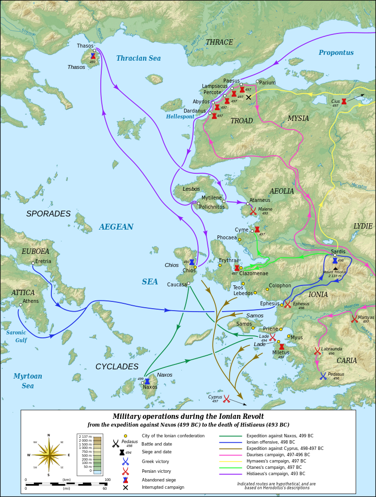
English: Map in English of the military operations during the Ionian Revolt which will lead to the Greco–Persian Wars. Notes: *The background map is a raster image embedded in the SVG file. *The routes shown are hypothetical, based on Herodotus's descriptions. Français : Carte en anglais des opérations militaires durant la révolte de l'Ionie qui va déclencher les Guerres médiques. Notes : *Le fond de carte est une image bitmap embarquée dans le fichier SVG. *Le tracé des routes suivies est figuratif et réalisé d'après les indications données par Hérodote. UTM projection – WGS84 datum Scale: 1:1,400,000 (precision: 350 m) |
| Date | (UTC) |
| Source |
|
| Author |
|
| Other versions |
Derivative works of this file: Ionian Revolt Campaign Map-el.svg
|


| This is a retouched picture, which means that it has been digitally altered from its original version. Modifications: Translated to English. The original can be viewed here: Ionian Revolt Campaign Map-fr.svg:
|
I, the copyright holder of this work, hereby publish it under the following licenses:
This file is licensed under the Creative Commons Attribution-Share Alike 3.0 Unported license.
- You are free:
- to share – to copy, distribute and transmit the work
- to remix – to adapt the work
- Under the following conditions:
- attribution – You must give appropriate credit, provide a link to the license, and indicate if changes were made. You may do so in any reasonable manner, but not in any way that suggests the licensor endorses you or your use.
- share alike – If you remix, transform, or build upon the material, you must distribute your contributions under the same or compatible license as the original.

|
Permission is granted to copy, distribute and/or modify this document under the terms of the GNU Free Documentation License, Version 1.2 or any later version published by the Free Software Foundation; with no Invariant Sections, no Front-Cover Texts, and no Back-Cover Texts. A copy of the license is included in the section entitled GNU Free Documentation License. |
You may select the license of your choice.
Original upload log
This image is a derivative work of the following images:
- File:Ionian_Revolt_Campaign_Map-fr.svg licensed with Cc-by-sa-3.0, GFDL
- 2009-06-27T12:58:50Z Sting 1330x1755 (1054965 Bytes) Oups! (some of the corrections haven't been saved)
- 2009-06-27T12:36:18Z Sting 1330x1755 (1053759 Bytes) Correction of the Antic shoreline around Miletus and Ephesus ; more precise position of some polis
- 2009-06-26T19:10:39Z Sting 1330x1755 (1054137 Bytes) == Summary == {{Information| |Description={{en|Map in French of the military operations during the [[:en:Ionian Revolt|Ionian Revolt]] which will lead to the [[:en:Greco–Persian Wars|Greco–Persian Wars]].''Notes:'' *''The
Uploaded with derivativeFX
File history
Click on a date/time to view the file as it appeared at that time.
| Date/Time | Thumbnail | Dimensions | User | Comment | |
|---|---|---|---|---|---|
| current | 15:20, 23 June 2011 | | 1,330 × 1,755 (1,007 KB) | AnonMoos | "Abandoned" spelling |
| 19:51, 15 January 2010 |  | 1,330 × 1,755 (1,007 KB) | MinisterForBadTimes | {{Information |Description={{en|Map in French of the military operations during the Ionian Revolt which will lead to the Greco–Persian Wars.<br/>''Notes:''<br/> *''The background map is a raster image e |
File usage
The following pages on the English Wikipedia use this file (pages on other projects are not listed):
Global file usage
The following other wikis use this file:
- Usage on af.wikipedia.org
- Usage on azb.wikipedia.org
- Usage on bg.wikipedia.org
- Usage on cs.wikipedia.org
- Usage on de.wikipedia.org
- Usage on et.wikipedia.org
- Usage on eu.wikipedia.org
- Usage on fa.wikipedia.org
- Usage on he.wikipedia.org
- Usage on hr.wikipedia.org
- Usage on id.wikipedia.org
- Usage on id.wikibooks.org
- Usage on it.wikipedia.org
- Usage on ja.wikipedia.org
- Usage on nl.wikipedia.org
- Usage on no.wikipedia.org
- Usage on pl.wikipedia.org
- Usage on sh.wikipedia.org
- Usage on sk.wikipedia.org
- Usage on sr.wikipedia.org
- Usage on ta.wikipedia.org
- Usage on tr.wikipedia.org
- Usage on vi.wikipedia.org