
File:Jeanne 2004-09-25 1615Z.jpg

Original file (5,200 × 6,800 pixels, file size: 7.08 MB, MIME type: image/jpeg)
| This is a file from the Wikimedia Commons. Information from its description page there is shown below. Commons is a freely licensed media file repository. You can help. |
Summary
| Description |
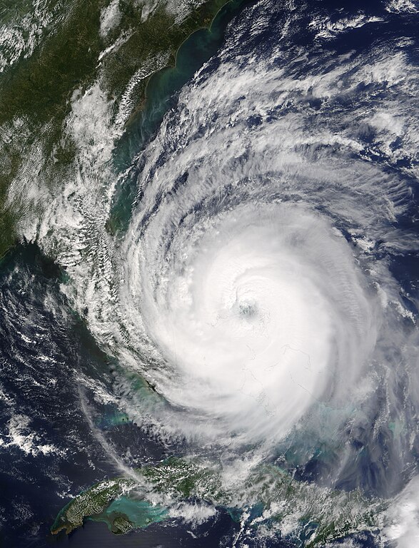
The eye of Hurricane Jeanne was centered over the narrow gap of water between Abaco Island, right, and Grand Bahama Island, left, on September 25, 2004, when the Moderate Resolution Imaging Spectroradiometer (MODIS) on NASA’s Terra satellite acquired this image. As the eye of the storm passed directly over Abaco Island and skirted the north coast of Grand Bahama Island, it strengthened from a Category 2 storm to a dangerous Category 3 hurricane. Between 8 a.m. and 11 a.m. EDT, sustained wind speeds went from 165 kilometers per hour (105 mph) to 185 kph (115 mph), according to the National Hurricane Center. This image was acquired at 10:15 a.m. EDT, during the strengthening period. When Jeanne reached Category 3 status, it became the fifth major hurricane of the 2004 Atlantic season. This image is available in additionalfifth resolutions from the MODIS Rapid Response Team. |
|||||
| Date | ||||||
| Source | http://visibleearth.nasa.gov/view_rec.php?id=6654 | |||||
| Author | Jacques Descloitres, MODIS Rapid Response Team, NASA/GSFC | |||||
| Permission (Reusing this file) |
|
|||||
| Other versions | Image:Hurricane jeanne 2004.jpg |

File history
Click on a date/time to view the file as it appeared at that time.
| Date/Time | Thumbnail | Dimensions | User | Comment | |
|---|---|---|---|---|---|
| current | 20:53, 4 October 2006 | | 5,200 × 6,800 (7.08 MB) | Good kitty | == Summary == {{Information |Description=The eye of Hurricane Jeanne was centered over the narrow gap of water between Abaco Island, right, and Grand Bahama Island, left, on September 25, 2004, when the Moderate Resolution Imaging Spectroradiometer (MODIS |
File usage
Global file usage
The following other wikis use this file:
- Usage on ca.wikipedia.org
- Usage on eo.wikipedia.org
- Usage on es.wikipedia.org
- Usage on fr.wikipedia.org
- Usage on pl.wikipedia.org
- Usage on pt.wikipedia.org
- Usage on simple.wikipedia.org
- Usage on uk.wikipedia.org
- Usage on www.wikidata.org
- Usage on zh.wikipedia.org
- Portal:美國/特色條目
- Wikipedia:典范条目/2014年5月
- 飓风珍妮的气象历史
- Talk:飓风珍妮的气象历史
- Wikipedia:优良条目/2014年7月
- Wikipedia:优良条目/2014年7月4日
- Wikipedia:优良条目/飓风珍妮的气象历史
- Wikipedia:典范条目/2014年5月4日
- Wikipedia:典范条目/飓风珍妮的气象历史
- Portal:美國/特色條目/125
- Wikipedia:典范条目/2016年1月
- Wikipedia:典范条目/2016年1月31日
- 飓风珍妮
- Wikipedia:典范条目/2018年4月
- Wikipedia:典范条目/2018年4月25日
- Wikipedia:典范条目/2021年10月
- Wikipedia:典范条目/2021年10月23日