
File:HawRiverMap1781.jpg

Original file (770 × 695 pixels, file size: 219 KB, MIME type: image/jpeg)
Summary[edit]
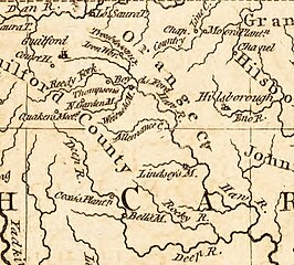
| Description |
A portion of Kitchin's 1791 map of North Carolina, featuring the locations of military interest from the American Revolutionary War, which depicts the territory between Hillsborough and Guilford Courthouse. |
|---|---|
| Source |
Original publication: London Magazine |
| Date |
June, 1781 |
| Author |
Thomas Kitchin |
| Permission (Reusing this file) |
See below.
|
Licensing[edit]
| This work is in the public domain in the United States because it was published (or registered with the U.S. Copyright Office) before January 1, 1929. |
 | This file is a candidate to be copied to Wikimedia Commons.
Any user may perform this transfer; refer to Wikipedia:Moving files to Commons for details. If this file has problems with attribution, copyright, or is otherwise ineligible for Commons, then remove this tag and DO NOT transfer it; repeat violators may be blocked from editing. Other Instructions
| ||
| |||
File history
Click on a date/time to view the file as it appeared at that time.
| Date/Time | Thumbnail | Dimensions | User | Comment | |
|---|---|---|---|---|---|
| current | 19:40, 24 January 2013 | | 770 × 695 (219 KB) | Cdtew (talk | contribs) | Uploading an old public-domain work using File Upload Wizard |
You cannot overwrite this file.