
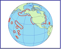
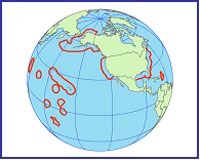
File:Global map of United States - EEZ.png
No higher resolution available.
Global_map_of_United_States_-_EEZ.png (200 × 160 pixels, file size: 35 KB, MIME type: image/png)
| This is a file from the Wikimedia Commons. Information from its description page there is shown below. Commons is a freely licensed media file repository. You can help. |
Summary
| Description |
English: Exclusive Economic Zone of the United States |
| Date | |
| Source | http://www.gc.noaa.gov/images/gcil_gis_eez_globe.png |
| Author | National Oceanic and Atmospheric Administration |
Licensing
This image is in the public domain because it contains materials that originally came from the U.S. National Oceanic and Atmospheric Administration, taken or made as part of an employee's official duties.
|
File history
Click on a date/time to view the file as it appeared at that time.
| Date/Time | Thumbnail | Dimensions | User | Comment | |
|---|---|---|---|---|---|
| current | 08:16, 15 August 2015 | | 200 × 160 (35 KB) | TheVirginiaHistorian | User created page with UploadWizard |
File usage
The following pages on the English Wikipedia use this file (pages on other projects are not listed):