
File:G. W. & C. B. Colton & Co. True Southern Pacific Railway c. 1881 UTA.jpg

Size of this preview: 800 × 300 pixels. Other resolutions: 320 × 120 pixels | 640 × 240 pixels | 1,024 × 384 pixels | 1,280 × 479 pixels | 2,560 × 959 pixels | 9,594 × 3,594 pixels.
Original file (9,594 × 3,594 pixels, file size: 9.22 MB, MIME type: image/jpeg)
| This is a file from the Wikimedia Commons. Information from its description page there is shown below. Commons is a freely licensed media file repository. You can help. |
Summary
| Title |
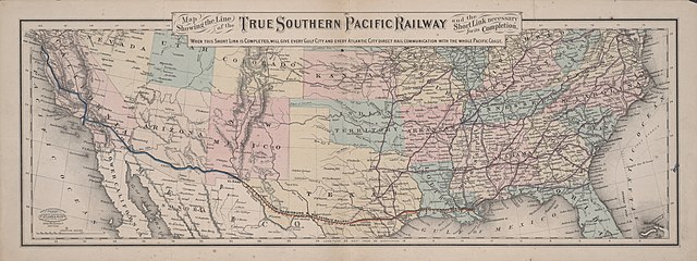
English: Map Showing the Line of the True Southern Pacific Railway and the Short Link necessary for its Completion |
||||||||||||||||||||||||||
| Description |
English: The Southern Pacific Railroad, chartered in California in 1865 to build a railroad between San Francisco and San Diego, was purchased in 1868 by the group of California railroad investors known as "the Big Four" – Leland Stanford, Collis P. Huntington, Charles Crocker, and Mark Hopkins – who merged it with their Central Pacific in 1870. By 1877 the S. P. stretched eastward into Arizona. By 1878 Huntington also had heavy investments in the Texas-based Galveston, Harrisburg and San Antonio Railway and the Texas and New Orleans Railroad. By 1881 the S. P. had reached El Paso and had control of both these railroads, the Louisiana Western Railroad Extension Company, and Morgan's Louisiana and Texas Railroad and Steamship Company. In 1883 the Southern Pacific and its affiliates completed yet another transcontinental route in 1883, when the construction crews of the G. H. & S. A. and the S. P. met just west of the Pecos River. By 1900 the Southern Pacific and its affiliates owned more miles of track than any other line in Texas.
|
||||||||||||||||||||||||||
| Date | circa 1881 | ||||||||||||||||||||||||||
| Source | UTA Libraries Cartographic Connections: map / text | ||||||||||||||||||||||||||
| Creator |
G. W. & C. B. Colton |
||||||||||||||||||||||||||
| Credit line |
English: The University of Texas at Arlington Libraries Special Collections |
||||||||||||||||||||||||||
| Geotemporal data | |||||||||||||||||||||||||||
| Map location | United States of America | ||||||||||||||||||||||||||
| Georeferencing | If inappropriate please set warp_status = skip to hide. | ||||||||||||||||||||||||||
| Place of publication | New York City | ||||||||||||||||||||||||||
| Archival data | |||||||||||||||||||||||||||
| Collection |
|
||||||||||||||||||||||||||
| Dimensions | height: 22.5 cm (8.8 in); width: 61.5 cm (24.2 in) | ||||||||||||||||||||||||||
| Medium |
color cerograph color lithograph |
||||||||||||||||||||||||||
| artwork-references |
Orsi, Richard (2005) Sunset Limited: The Southern Pacific Railroad and the Development of the American West, 1850-1930, Berkeley: University of California Press Peterson, Anne The Southern Pacific Railroad: The Road of a Thousand Wonders, Dallas: DeGolyer Library, SMU, p. 2,005 |
||||||||||||||||||||||||||
Licensing

|
This file was provided to Wikimedia Commons by the University of Texas at Arlington Libraries as part of a cooperation project. The University of Texas at Arlington Libraries is part of the University of Texas at Arlington, a public research university located in Arlington, Texas.
|
This work was published before January 1, 1929 and it is anonymous or pseudonymous due to unknown authorship. It is in the public domain in the United States as well as countries and areas where the copyright terms of anonymous or pseudonymous works are 95 years or fewer since publication.
|
File history
Click on a date/time to view the file as it appeared at that time.
| Date/Time | Thumbnail | Dimensions | User | Comment | |
|---|---|---|---|---|---|
| current | 15:34, 13 April 2022 | 9,594 × 3,594 (9.22 MB) | Michael Barera | == {{int:filedesc}} == {{Map |title = {{en|'''''Map Showing the Line of the True Southern Pacific Railway and the Short Link necessary for its Completion'''''}} |description = {{en|The Southern Pacific Railroad, chartered in California in 1865 to build a railroad between San Francisco and San Diego, was purchased in 1868 by the group of California railroad investors known as "the Big Four" – Leland Stanford, Collis P. Huntington, Charles Crocker, and Mark Hopkins – who mer... |
File usage
The following pages on the English Wikipedia use this file (pages on other projects are not listed):
Global file usage
The following other wikis use this file:
- Usage on de.wikipedia.org
- Usage on es.wikipedia.org
- Usage on fr.wikipedia.org
- Usage on hu.wikipedia.org
- Usage on it.wikipedia.org
- Usage on pt.wikipedia.org