
File:Fort Wagner. Morris Island LOC gvhs01.vhs00230.jpg
Size of this preview: 366 × 599 pixels. Other resolutions: 146 × 240 pixels | 293 × 480 pixels | 469 × 768 pixels | 625 × 1,024 pixels | 1,583 × 2,591 pixels.
Original file (1,583 × 2,591 pixels, file size: 727 KB, MIME type: image/jpeg)
| This is a file from the Wikimedia Commons. Information from its description page there is shown below. Commons is a freely licensed media file repository. You can help. |
Summary
| Description |
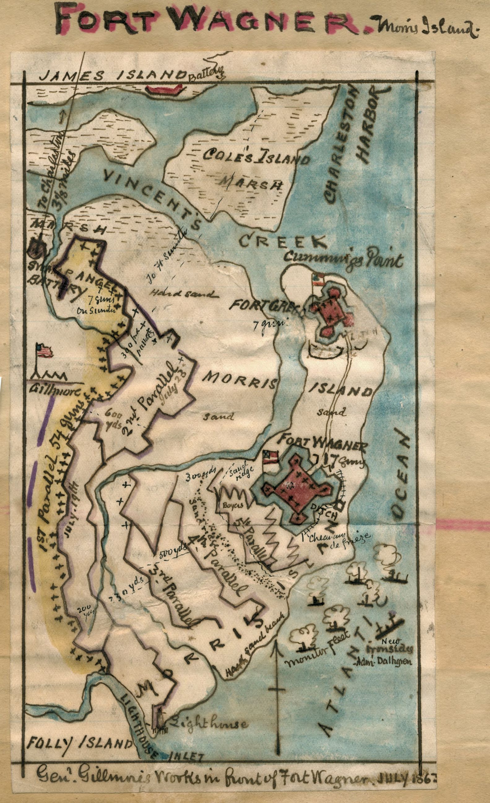
English: In July 1863, Union Generals Gillmore and Dahlgren hoped to take Fort Wagner, on Morris Island in Charleston Harbor, in order to gain a vantage point from which to launch an attack on the city of Charleston. Strongly defended, the first Union assaults (July 10th and 18th) resulted in extremely high casualties. Gillmore began formal siege operations and had reached to base of the fort by September 6th. The Confederate forces abandoned the fort during the night. This map includes Folly Island to the south of Morris Island, Charleston Harbor to the northeast and Coles Island to the north. |
||
| Title | Fort Wagner. Morris Island | ||
| Shelf ID | https://www.loc.gov/item/001-CABIB20007466/ | ||
| Date | |||
| Source | https://www.loc.gov/item/gvhs01.vhs00230/ | ||
| Author | Sneden, Robert Knox | ||
| Permission (Reusing this file) |
|
||
| Other versions |
|
||
| Location | United States · South Carolina · Fort Wagner · Morris Island | ||
| Part of | Military Battles And Campaigns · American Memory · Civil War Maps · Geography And Map Division | ||
| Subject | Morris Island, Battle Of, S.C · Civil War · United States · Maps · Fort Wagner (S.C.) · Fort Wagner · Morris Island · South Carolina · Morris Island, Battle Of, S.C., (July 10-Spetember 7) · History |


Licensing
|
This is a faithful photographic reproduction of a two-dimensional, public domain work of art. The work of art itself is in the public domain for the following reason:
The official position taken by the Wikimedia Foundation is that "faithful reproductions of two-dimensional public domain works of art are public domain".
This photographic reproduction is therefore also considered to be in the public domain in the United States. In other jurisdictions, re-use of this content may be restricted; see Reuse of PD-Art photographs for details. | ||||
File history
Click on a date/time to view the file as it appeared at that time.
| Date/Time | Thumbnail | Dimensions | User | Comment | |
|---|---|---|---|---|---|
| current | 21:16, 25 August 2018 | | 1,583 × 2,591 (727 KB) | Fæ | LOC Maps https://www.loc.gov/item/gvhs01.vhs00230/ #7490 |
File usage
The following pages on the English Wikipedia use this file (pages on other projects are not listed):
Global file usage
The following other wikis use this file:
- Usage on azb.wikipedia.org
- Usage on ro.wikipedia.org