
File:Formative Era sites.svg

Size of this PNG preview of this SVG file: 629 × 459 pixels. Other resolutions: 320 × 234 pixels | 640 × 467 pixels | 1,024 × 747 pixels | 1,280 × 934 pixels | 2,560 × 1,868 pixels.
Original file (SVG file, nominally 629 × 459 pixels, file size: 100 KB)
| This is a file from the Wikimedia Commons. Information from its description page there is shown below. Commons is a freely licensed media file repository. You can help. |
Summary

|
This SVG file contains embedded text that can be translated into your language, using any capable SVG editor, text editor or the SVG Translate tool. For more information see: About translating SVG files. |
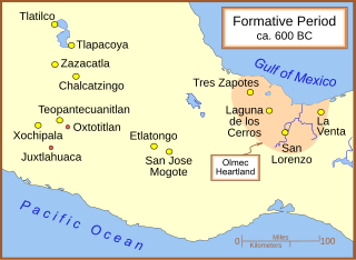
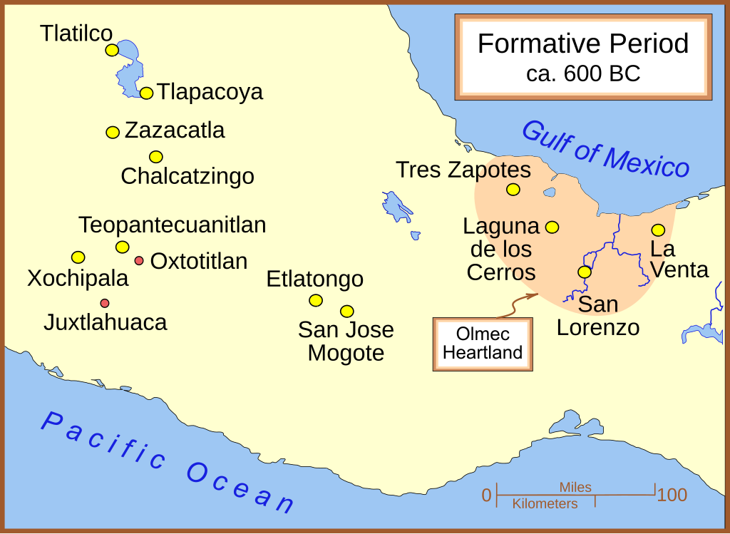
A map of the better known Mexican sites from the Formative Era, with a very general date of 600 BC (BCE). The yellow sites are known villages and towns. The smaller red dots mark locations where artifacts or art has been found without evidence of habitation.
Other versions
Part of a series:
-
 }Formative Period sites in Central Mexico
 -
 Formative Period sites in Southeastern Mesoamerica
 -
 Map of the Olmec Heartland
 -
 Classic era sites in Central Mexico
 -
 Site with early evidence for ballplaying
 -
 Maya sites in northern Yucatan 800 AD


Other versions
Licensing
I, the copyright holder of this work, hereby publish it under the following licenses:

|
Permission is granted to copy, distribute and/or modify this document under the terms of the GNU Free Documentation License, Version 1.2 or any later version published by the Free Software Foundation; with no Invariant Sections, no Front-Cover Texts, and no Back-Cover Texts. A copy of the license is included in the section entitled GNU Free Documentation License. |
| This file is licensed under the Creative Commons Attribution-Share Alike 3.0 Unported license. | ||
| ||
| This licensing tag was added to this file as part of the GFDL licensing update. |
This file is licensed under the Creative Commons Attribution-Share Alike 2.5 Generic, 2.0 Generic and 1.0 Generic license.
- You are free:
- to share – to copy, distribute and transmit the work
- to remix – to adapt the work
- Under the following conditions:
- attribution – You must give appropriate credit, provide a link to the license, and indicate if changes were made. You may do so in any reasonable manner, but not in any way that suggests the licensor endorses you or your use.
- share alike – If you remix, transform, or build upon the material, you must distribute your contributions under the same or compatible license as the original.
You may select the license of your choice.
File history
Click on a date/time to view the file as it appeared at that time.
| Date/Time | Thumbnail | Dimensions | User | Comment | |
|---|---|---|---|---|---|
| current | 14:22, 29 January 2009 | | 629 × 459 (100 KB) | Madman2001 | Added Xochipala |
| 04:01, 18 March 2007 |  | 613 × 459 (98 KB) | Madman2001 | a couple of fixes | |
| 05:41, 25 February 2007 |  | 613 × 459 (98 KB) | Madman2001 | some modifications to match image:Olmec Heartland Overview v2.sg | |
| 21:09, 24 February 2007 |  | 613 × 459 (97 KB) | Madman2001 | minor modifications | |
| 21:48, 22 February 2007 |  | 613 × 459 (97 KB) | Madman2001 | Added another site & adjusted colours | |
| 03:36, 22 February 2007 |  | 613 × 459 (96 KB) | Madman2001 | A few small fixes | |
| 03:33, 22 February 2007 |  | 607 × 456 (59 KB) | Madman2001 | A map of the better known Mexican sites from the Formative Era. |
File usage
The following pages on the English Wikipedia use this file (pages on other projects are not listed):
- Chalcatzingo
- Juxtlahuaca
- Mesoamerican chronology
- Mirrors in Mesoamerican culture
- Olmec influences on Mesoamerican cultures
- Olmecs
- Oxtotitlán
- Regional communications in ancient Mesoamerica
- San José Mogote
- Teopantecuanitlan
- Xochipala
- Zazacatla
- User:Abyssal/Portal Prehistory of North America
- User:Abyssal/Prehistory of North America/DYK/46
Global file usage
The following other wikis use this file:
- Usage on be.wikipedia.org
- Usage on bg.wikipedia.org
- Usage on de.wikipedia.org
- Usage on en.wikibooks.org
- Usage on es.wikipedia.org
- Usage on fa.wikipedia.org
- Usage on fi.wikipedia.org
- Usage on fr.wikipedia.org
- Usage on gl.wikipedia.org
- Usage on hy.wikipedia.org
- Usage on it.wikipedia.org
- Usage on ja.wikipedia.org
- Usage on ka.wikipedia.org
- Usage on lt.wikipedia.org
- Usage on pl.wikipedia.org
- Usage on uz.wikipedia.org
- Usage on www.wikidata.org
- Usage on zh.wikipedia.org