
File:Fiji detail.jpg

Size of this preview: 589 × 600 pixels. Other resolutions: 236 × 240 pixels | 600 × 611 pixels.
Original file (600 × 611 pixels, file size: 50 KB, MIME type: image/jpeg)
| This is a file from the Wikimedia Commons. Information from its description page there is shown below. Commons is a freely licensed media file repository. You can help. |

|
This map has been uploaded by Electionworld from en.wikipedia.org to enable the |
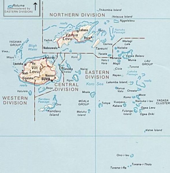
PNG map of Fiji from CIA World Factbook.
This image is in the public domain because it contains materials that originally came from the United States Central Intelligence Agency's World Factbook.
|
 |
File history
Click on a date/time to view the file as it appeared at that time.
| Date/Time | Thumbnail | Dimensions | User | Comment | |
|---|---|---|---|---|---|
| current | 12:51, 30 June 2010 | | 600 × 611 (50 KB) | Telim tor | exchanged positions of Tuvana-i-Ra and Tuvana-i-Tholo (i-Ra is the southwestern one, see also [http://www.un.org/Depts/Cartographic/map/profile/Fiji.pdf this map] (PDF) |
| 19:45, 27 November 2006 |  | 600 × 611 (48 KB) | Electionworld | {{ew|en|Pascal}} PNG map of Fiji from CIA World Factbook. {{PD-USGov-CIA-WF}} Category:Maps of Fiji |
File usage
The following pages on the English Wikipedia use this file (pages on other projects are not listed):
Global file usage
The following other wikis use this file:
- Usage on avk.wikipedia.org
- Usage on az.wikipedia.org
- Usage on be.wikipedia.org
- Usage on cs.wikipedia.org
- Usage on de.wikipedia.org
- Usage on es.wikinews.org
- Usage on io.wikipedia.org
- Usage on ka.wikipedia.org
- Usage on pl.wikipedia.org
- Usage on ru.wikipedia.org
- Usage on tr.wikipedia.org
- Usage on uk.wikipedia.org
- Usage on www.wikidata.org