File:England of the Malory Candidates.png

Page contents not supported in other languages.
This is a file from the Wikimedia Commons
From Wikipedia, the free encyclopedia

Original file(775 × 1,151 pixels, file size: 255 KB, MIME type: image/png)

Summary

Description
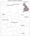
English: Locations on this map and their relevance:

- Newbold Revel: Home of Sir Thomas Malory of Newbold Revel.

- London: Most frequent place of imprisonment of Malory of Newbold Revel, and location of William Caxton, printer of Le Morte Darthur.

- Moreton Corbet and Papworth: Childhood and adulthood homes of Malory of Papworth St. Agnes.

- Line from Chester to the Wash: Linguist Angus McIntosh determined that the dialect of Le Morte Darthur is characteristic of roughly anywhere north of this line, though "most at home" in Lincolnshire.
Date
Source Own work
Author Jeblinton
Camera location53° 00′ 00″ N, 1° 00′ 00″ W Kartographer map based on OpenStreetMap.View this and other nearby images on: OpenStreetMapinfo

Created in Jupyter Notebook using Geopy, Geopandas, and Matplotlib

Licensing

I, the copyright holder of this work, hereby publish it under the following license:
w:en:Creative Commons
attribution share alike
This file is licensed under the Creative Commons Attribution-Share Alike 4.0 International license.
You are free:
  • to share – to copy, distribute and transmit the work
  • to remix – to adapt the work
Under the following conditions:
  • attribution – You must give appropriate credit, provide a link to the license, and indicate if changes were made. You may do so in any reasonable manner, but not in any way that suggests the licensor endorses you or your use.
  • share alike – If you remix, transform, or build upon the material, you must distribute your contributions under the same or compatible license as the original.

Captions

Zoomed view of England showing locations relevant to the question of Thomas Malory's identity

Items portrayed in this file

depicts

image/png

511aa90dd388a604cf1df0a6c21d1174b19d176a

278,066 byte

1,191 pixel

878 pixel

53°0'0.000"N, 1°0'0.000"W

12 June 2023

File history

Click on a date/time to view the file as it appeared at that time.

Date/TimeThumbnailDimensionsUserComment
current17:37, 11 July 2023Thumbnail for version as of 17:37, 11 July 2023775 × 1,151 (255 KB)JeblintonAdded Northumberland (location of Northern campaign) and Ribston (location of Cambridge MS)
21:45, 13 June 2023Thumbnail for version as of 21:45, 13 June 2023878 × 1,191 (272 KB)JeblintonAdded color and expanded scale for clarity
20:45, 12 June 2023Thumbnail for version as of 20:45, 12 June 2023993 × 1,196 (267 KB)JeblintonCropped unneeded whitespace
20:15, 12 June 2023Thumbnail for version as of 20:15, 12 June 20231,800 × 1,200 (283 KB)JeblintonUploaded own work with UploadWizard
The following pages on the English Wikipedia use this file (pages on other projects are not listed):

Metadata