
File:Distant swans, Guyhirn Wash - The Nene Washes - geograph.org.uk - 1737307.jpg

Size of this preview: 800 × 600 pixels. Other resolutions: 320 × 240 pixels | 640 × 480 pixels | 1,024 × 768 pixels | 1,280 × 960 pixels | 2,560 × 1,920 pixels | 2,848 × 2,136 pixels.
Original file (2,848 × 2,136 pixels, file size: 3.04 MB, MIME type: image/jpeg)
| This is a file from the Wikimedia Commons. Information from its description page there is shown below. Commons is a freely licensed media file repository. You can help. |
Summary
| Description |
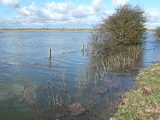
English: Distant swans, Guyhirn Wash - The Nene Washes The Nene Washes is an area of seasonally flooding wet grassland (washland) lying between the south bank of the River Nene and another bank south of Mortons Leam and stretching for 12 miles from Peterborough to Guyhirn. The washes have local village names, Guyhirn Wash, Whittlesey Wash etc but are collectively known as The Nene Washes. One of the earliest Fenland drains, Mortons Leam, dug in the late 15th century flows in almost a straight line parallel to the current course of the River Nene through the washes. At times of potential flooding along The Nene Valley water is channelled from The River Nene into Mortons Leam and onto the washes. Water is released from The Washes via a sluice gate near Guyhirn and back into the River Nene at low tide when the threat of flooding the surrounding fenland has subsided. |
| Date | |
| Source | From geograph.org.uk |
| Author | Richard Humphrey |
| Attribution (required by the license) | Richard Humphrey / Distant swans, Guyhirn Wash - The Nene Washes / |
| Camera location | | View this and other nearby images on: OpenStreetMap |
|---|
_heading:292.00&language=en)
| Object location | | View this and other nearby images on: OpenStreetMap |
|---|
_heading:292.00&language=en)
Licensing

|
This image was taken from the Geograph project collection. See this photograph's page on the Geograph website for the photographer's contact details. The copyright on this image is owned by Richard Humphrey and is licensed for reuse under the Creative Commons Attribution-ShareAlike 2.0 license.
|
This file is licensed under the Creative Commons Attribution-Share Alike 2.0 Generic license.
Attribution: Richard Humphrey
- You are free:
- to share – to copy, distribute and transmit the work
- to remix – to adapt the work
- Under the following conditions:
- attribution – You must give appropriate credit, provide a link to the license, and indicate if changes were made. You may do so in any reasonable manner, but not in any way that suggests the licensor endorses you or your use.
- share alike – If you remix, transform, or build upon the material, you must distribute your contributions under the same or compatible license as the original.
File history
Click on a date/time to view the file as it appeared at that time.
| Date/Time | Thumbnail | Dimensions | User | Comment | |
|---|---|---|---|---|---|
| current | 15:01, 5 March 2011 | | 2,848 × 2,136 (3.04 MB) | GeographBot | == {{int:filedesc}} == {{Information |description={{en|1=Distant swans, Guyhirn Wash - The Nene Washes The Nene Washes is an area of seasonally flooding wet grassland (washland) lying between the south bank of the River Nene and another bank south of Mort |
File usage
The following pages on the English Wikipedia use this file (pages on other projects are not listed):
Global file usage
The following other wikis use this file:
- Usage on www.wikidata.org