
File:Dirtlow Rake - geograph.org.uk - 2368667.jpg
Dirtlow_Rake_-_geograph.org.uk_-_2368667.jpg (800 × 531 pixels, file size: 163 KB, MIME type: image/jpeg)
| This is a file from the Wikimedia Commons. Information from its description page there is shown below. Commons is a freely licensed media file repository. You can help. |
Summary
| Description |
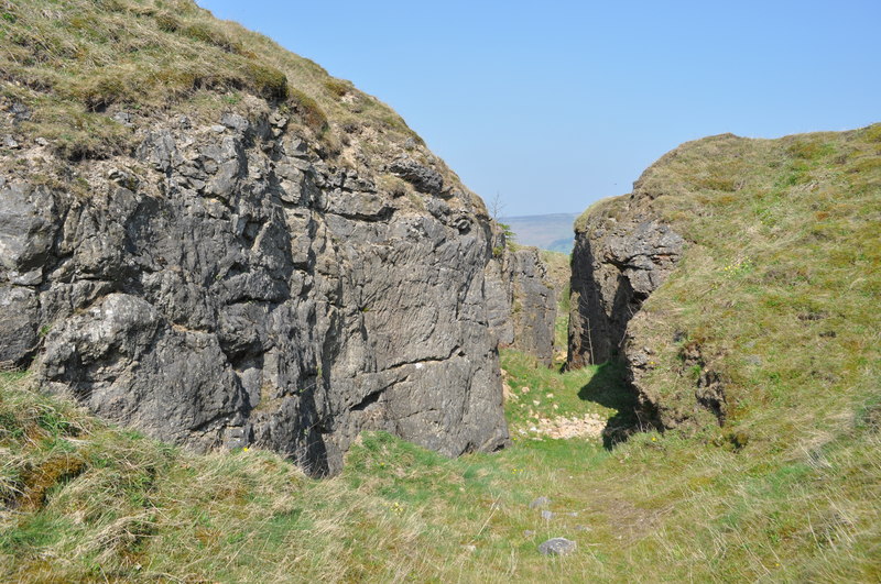
English: Dirtlow Rake, near to Castleton, Derbyshire, Great Britain.
Dirtlow Rake is a series of open and underground workings following a series of mineral veins. Rake is another meaning for vein, although the veins are long and sometimes rather thick. This rake runs along a fault line, horizontal slikensides have been observed, vertical displacement has been estimated at 20-30m. The lead and Zinc veins here (Galena/Sphalerite) have been mined for centuries, later on the gangue minerals (waste) became valuable and mined in their own right. Notably calcite, barytes and flurospar, its also worth mentioning not far away the flurospar 'blue john' is/was extracted. The veins formed when around 2km down hot fluids around 120 degrees C dissolved ions from the shales alongside<a href="https://www.geograph.org.uk/photo/2366518">SK1383 : Mam Tor</a>. These fluids moved laterally before reaching oxygenated and slightly sulphuric ground waters in the limestone, this caused the minerals to precipitate out. These waters moved along cracks and faults. The site is on private land and permission to enter must be sought. This description was sourced from 'The geological setting of the lead mines in the northern part of the White Peak, Derbyshire' by Trevor D Ford (2010). |
| Date | |
| Source | From geograph.org.uk; transferred by User:Rubberstamp using geograph_org2commons. |
| Author | Ashley Dace |
| Permission (Reusing this file) |
Creative Commons Attribution Share-alike license 2.0 |
| Attribution (required by the license) | Ashley Dace / Dirtlow Rake / |
| Camera location | | View this and other nearby images on: OpenStreetMap |
|---|
| Object location | | View this and other nearby images on: OpenStreetMap |
|---|
_region:GB-GBN_heading:90.00&language=en)
Licensing

|
This image was taken from the Geograph project collection. See this photograph's page on the Geograph website for the photographer's contact details. The copyright on this image is owned by Ashley Dace and is licensed for reuse under the Creative Commons Attribution-ShareAlike 2.0 license.
|
- You are free:
- to share – to copy, distribute and transmit the work
- to remix – to adapt the work
- Under the following conditions:
- attribution – You must give appropriate credit, provide a link to the license, and indicate if changes were made. You may do so in any reasonable manner, but not in any way that suggests the licensor endorses you or your use.
- share alike – If you remix, transform, or build upon the material, you must distribute your contributions under the same or compatible license as the original.
File history
Click on a date/time to view the file as it appeared at that time.
| Date/Time | Thumbnail | Dimensions | User | Comment | |
|---|---|---|---|---|---|
| current | 19:50, 6 May 2011 | | 800 × 531 (163 KB) | File Upload Bot (Magnus Manske) |
File usage
Global file usage
The following other wikis use this file:
- Usage on ru.wikipedia.org