
File:Devon UK location map.svg

Size of this PNG preview of this SVG file: 653 × 600 pixels. Other resolutions: 261 × 240 pixels | 523 × 480 pixels | 836 × 768 pixels | 1,115 × 1,024 pixels | 2,229 × 2,048 pixels | 1,292 × 1,187 pixels.
Original file (SVG file, nominally 1,292 × 1,187 pixels, file size: 2.43 MB)
| This is a file from the Wikimedia Commons. Information from its description page there is shown below. Commons is a freely licensed media file repository. You can help. |
| Description |
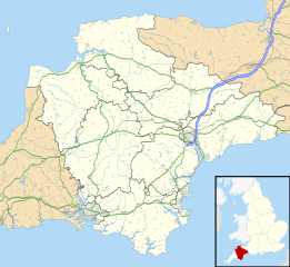
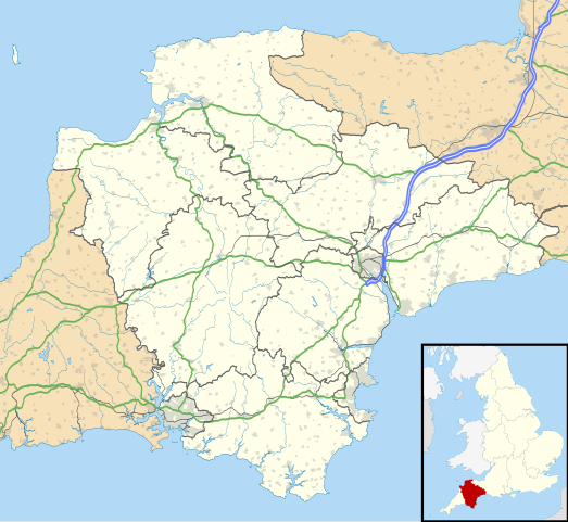
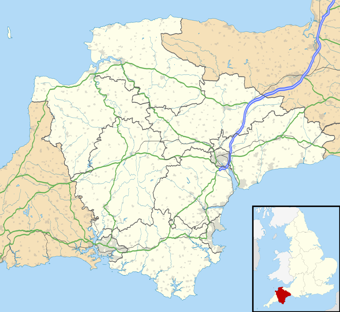
Map of Devon, UK with the following information shown:
Equirectangular map projection on WGS 84 datum, with N/S stretched 150% Geographic limits:
|
| Date | |
| Source |
|
| Author | Nilfanion, created using Ordnance Survey data |
| Permission (Reusing this file) |
This file is licensed under the Creative Commons Attribution-Share Alike 3.0 Unported license. Attribution: Contains Ordnance Survey data © Crown copyright and database right
|
| Other versions | File:Devon UK district map (blank).svg - Blank map with administrative borders only. |
.svg)
File history
Click on a date/time to view the file as it appeared at that time.
| Date/Time | Thumbnail | Dimensions | User | Comment | |
|---|---|---|---|---|---|
| current | 18:48, 26 September 2010 | | 1,292 × 1,187 (2.43 MB) | Nilfanion | tweak motorways... |
| 23:56, 6 September 2010 |  | 1,292 × 1,187 (2.64 MB) | Nilfanion | Tweaking urban areas, road colours and boundary lines | |
| 20:54, 4 September 2010 |  | 1,292 × 1,187 (2.4 MB) | Nilfanion | {{Information |Description=Map of Devon, UK with the following information shown: *Administrative borders *Coastline, lakes and rivers *Motorways and primary routes *Urban areas Equirectangular map projection on WGS 84 datum, with N/S stretch |
File usage
More than 100 pages use this file. The following list shows the first 100 pages that use this file only. A full list is available.
- Appledore, Mid Devon
- Appledore, Torridge
- Ashburton, Devon
- Aveton Gifford
- Axminster
- Bantham Cross
- Barnstaple
- Beer, Devon
- Bideford
- Bradninch
- Braunton
- Bridford
- Brixham
- Buckfastleigh
- Budleigh Salterton
- Chagford
- Chudleigh Knighton
- Clovelly
- Combe, Buckfastleigh, Devon
- Combe, Yealmpton, Devon
- Combe Martin
- Combe Pafford
- Commando Training Centre Royal Marines
- Crediton
- Crownhill
- Croyde
- Cullompton
- Dartington
- Dartmouth, Devon
- Dawlish
- Dawlish Warren
- Devonport, Plymouth
- Drake's Island
- Drizzlecombe
- East Portlemouth
- Eggbuckland
- Exeter Airport
- Exmouth
- Fort Bovisand
- Great Torrington
- Grey Wethers
- Grimspound
- Hartland, Devon
- Hatherleigh
- Heavitree
- Hembury
- Holne
- Honiton
- Horrabridge
- Ilfracombe
- Instow
- Ivybridge
- Kents Cavern
- Kingsbridge
- Laira
- Langtree
- Leigham
- List of places in Devon
- Little Torrington
- Lydford
- Lynmouth
- Lynton
- Merrivale, Devon
- Moretonhampstead
- Morice Town
- Mutley Plain
- Newton Abbot
- Northam, Devon
- Okehampton
- Oldway Mansion
- Ottery St Mary
- Paignton
- Plymouth City Airport
- Plymouth Gin
- Plympton
- Poundsgate
- Princetown
- RAF Chivenor
- RM Chivenor
- Rougemont Castle
- Royal Citadel, Plymouth
- Salcombe
- Sampford Courtenay
- Seaton, Devon
- Sidmouth
- South Pool
- South Tawton
- St Budeaux
- Starcross
- Start Point, Devon
- Stonehouse, Plymouth
- Tavistock
- Teignmouth
- Tiverton, Devon
- Torquay
- Totnes
- Totnes Castle
- Westward Ho!
- Widecombe in the Moor
- Yealmpton
View more links to this file.
Global file usage
The following other wikis use this file:
- Usage on ar.wikipedia.org
- Usage on arz.wikipedia.org
- Usage on azb.wikipedia.org
- هونیتون
- هولسوورتی، دوون
- هارتلند، دوون
- هاترلی، دوون
- نیوتون آبوت
- نورث تاوتون
- نورتهام، دوون
- مورتونهامپستید
- کینقزبریج
- کولیتون، دوون
- کردیتون
- کالومپتون
- قریت تورینقتون
- سیدموث
- سیتون، دوون
- ساوت مولتون
- سالکومب
- دونپورت، پلیموث
- داولیش
- دارتموث، دوون
- چالملی
- چاقفورد
- چادلی
- تیورتون، دوون
- تینموث
- تورکی
- توتنس
- تاویستوک، دوون
- پینتون
- پلمپتون
- بیدفورد
- بووی تریسی
- بودلی سالترتون
- بریکسهام
- برانسکومب
- برادنینچ
- باکفستلی
- بارنستاپل
- آیویبریج
- ایلفراکم
- اوکهامپتون
- اوتری سنت ماری
- اکسمینستر
- اکسموث
- اشبورتون، دوون
- Usage on bg.wikipedia.org
View more global usage of this file.