
File:Dalguise Station, Perthshire - geograph.org.uk - 59522.jpg
No higher resolution available.
Dalguise_Station,_Perthshire_-_geograph.org.uk_-_59522.jpg (640 × 480 pixels, file size: 38 KB, MIME type: image/jpeg)
| This is a file from the Wikimedia Commons. Information from its description page there is shown below. Commons is a freely licensed media file repository. You can help. |
Summary
| Description |
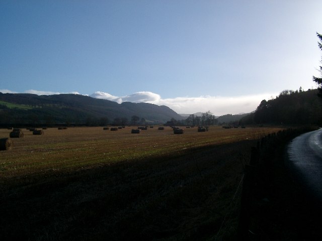
English: Dalguise Station, Perthshire. Taken from the B989, this shows Dalguise Station in the centre (closed 1965 and now a private house) and the Tay Valley upstream of Dunkeld. The Tay runs not far to the left of this photo. The land shown was part of the original Tay flood plain, and irregularly (maybe four times in the last 15 years), the river has burst the Victorian flood banks (and sometime the railway embankment too) to flood the valley anew. With Global Warming, there's a good change this land will flood regularly. Look on the straw bales while ye may! |
| Date | |
| Source | From geograph.org.uk |
| Author | Kirsty Smith |
| Attribution (required by the license) | Kirsty Smith / Dalguise Station, Perthshire / |
| Camera location | | View this and other nearby images on: OpenStreetMap |
|---|
_region:GB-GBN_heading:157.00&language=en)
| Object location | | View this and other nearby images on: OpenStreetMap |
|---|
_heading:157.00&language=en)
Licensing

|
This image was taken from the Geograph project collection. See this photograph's page on the Geograph website for the photographer's contact details. The copyright on this image is owned by Kirsty Smith and is licensed for reuse under the Creative Commons Attribution-ShareAlike 2.0 license.
|
This file is licensed under the Creative Commons Attribution-Share Alike 2.0 Generic license.
Attribution: Kirsty Smith
- You are free:
- to share – to copy, distribute and transmit the work
- to remix – to adapt the work
- Under the following conditions:
- attribution – You must give appropriate credit, provide a link to the license, and indicate if changes were made. You may do so in any reasonable manner, but not in any way that suggests the licensor endorses you or your use.
- share alike – If you remix, transform, or build upon the material, you must distribute your contributions under the same or compatible license as the original.
File history
Click on a date/time to view the file as it appeared at that time.
| Date/Time | Thumbnail | Dimensions | User | Comment | |
|---|---|---|---|---|---|
| current | 14:17, 30 January 2010 | | 640 × 480 (38 KB) | GeographBot | == {{int:filedesc}} == {{Information |description={{en|1=Dalguise Station, Perthshire. Taken from the B989, this shows Dalguise Station in the centre (closed 1965 and now a private house) and the Tay Valley upstream of Dunkeld. The Tay runs not far to the |
File usage
The following pages on the English Wikipedia use this file (pages on other projects are not listed):
Global file usage
The following other wikis use this file:
- Usage on www.wikidata.org