
File:Cwm-y-glo near to station site geograph-3117896-by-Ben-Brooksbank.jpg
Size of this preview: 800 × 487 pixels. Other resolutions: 320 × 195 pixels | 640 × 390 pixels | 1,024 × 623 pixels | 1,280 × 779 pixels | 2,377 × 1,447 pixels.
Original file (2,377 × 1,447 pixels, file size: 2.5 MB, MIME type: image/jpeg)
| This is a file from the Wikimedia Commons. Information from its description page there is shown below. Commons is a freely licensed media file repository. You can help. |
Summary
| Description |
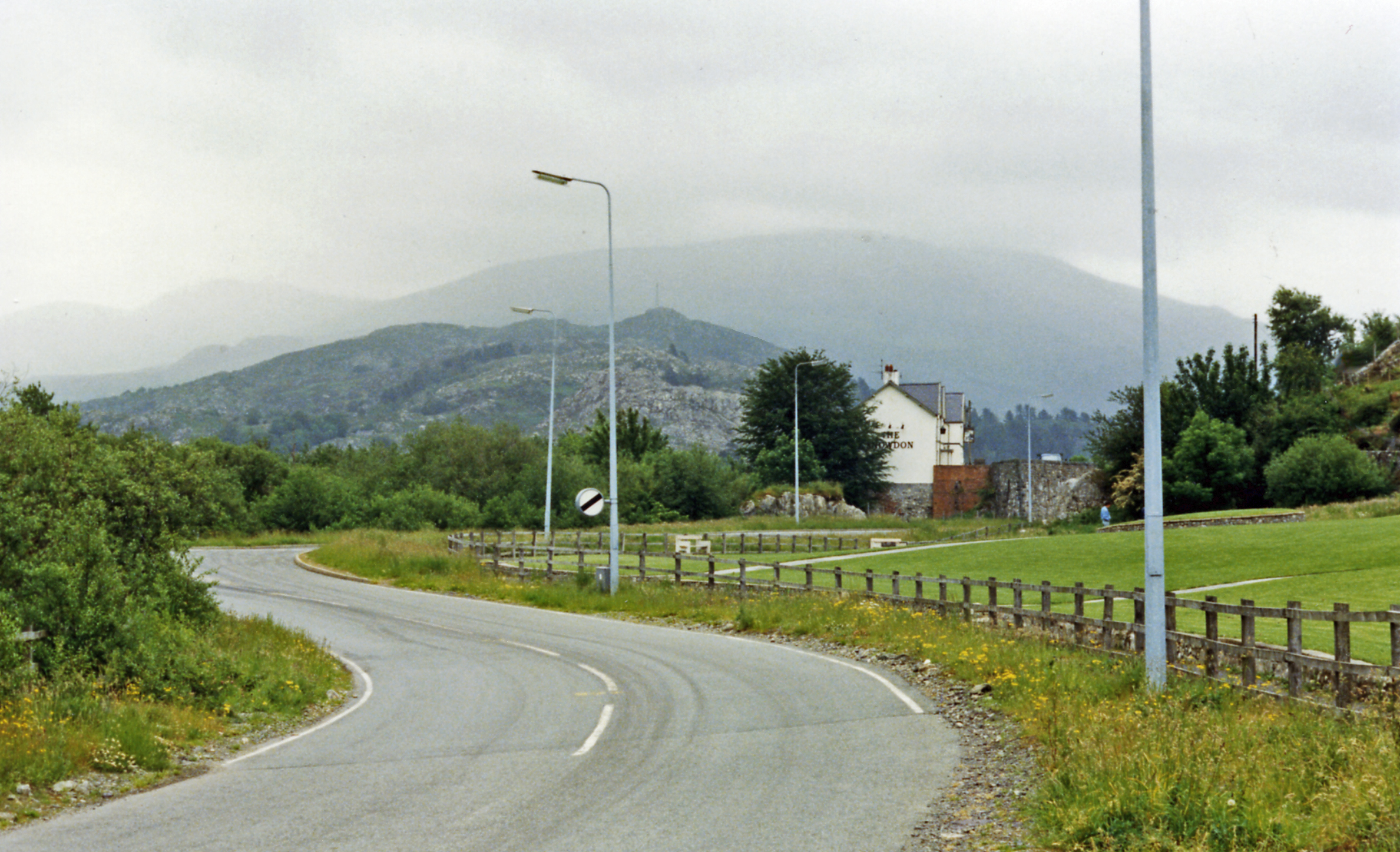
English: Near site of Cwm-y-glo station towards Llanberis Pass. View SE on A4086 near Llyn Padarn, the railway having been off frame to the left: ex-LNW Caernarvon - Llanberis branch. The station was closed to regular passenger services from 22/9/30 (goods 29/6/64), but the excursions ran to Llanberis until 7/9/62 (goods 7/12/64). This is the way to Snowdon and its Mountain Railway - off to the right: in the centre background is Elidir Fawr (3,026 ft.). |
| Date | |
| Source | From geograph.org.uk |
| Author | Ben Brooksbank |
| Permission (Reusing this file) |
Creative Commons Attribution Share-alike license 2.0 |
| Attribution (required by the license) | Ben Brooksbank / Near site of Cwm-y-glo station towards Llanberis Pass / |
| Camera location | | View this and other nearby images on: OpenStreetMap |
|---|
Licensing

|
This image was taken from the Geograph project collection. See this photograph's page on the Geograph website for the photographer's contact details. The copyright on this image is owned by Ben Brooksbank and is licensed for reuse under the Creative Commons Attribution-ShareAlike 2.0 license.
|
This file is licensed under the Creative Commons Attribution-Share Alike 2.0 Generic license.
Attribution: Ben Brooksbank
- You are free:
- to share – to copy, distribute and transmit the work
- to remix – to adapt the work
- Under the following conditions:
- attribution – You must give appropriate credit, provide a link to the license, and indicate if changes were made. You may do so in any reasonable manner, but not in any way that suggests the licensor endorses you or your use.
- share alike – If you remix, transform, or build upon the material, you must distribute your contributions under the same or compatible license as the original.
File history
Click on a date/time to view the file as it appeared at that time.
| Date/Time | Thumbnail | Dimensions | User | Comment | |
|---|---|---|---|---|---|
| current | 20:19, 27 September 2012 | | 2,377 × 1,447 (2.5 MB) | Chevin | == {{int:filedesc}} == {{Information |Description={{en|1='''Near site of Cwm-y-glo station towards Llanberis Pass.'''<br/> View SE on A4086 near Llyn Padarn, the railway having been off frame to the left: ex-LNW Caernarvon - Llanberis branch. The stati... |
File usage
The following pages on the English Wikipedia use this file (pages on other projects are not listed):
Global file usage
The following other wikis use this file:
- Usage on www.wikidata.org