
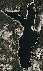
File:Courtright Reservoir Aerial.jpg

Size of this preview: 363 × 599 pixels. Other resolutions: 145 × 240 pixels | 291 × 480 pixels | 465 × 768 pixels | 621 × 1,024 pixels | 1,241 × 2,048 pixels | 5,728 × 9,448 pixels.
Original file (5,728 × 9,448 pixels, file size: 73.49 MB, MIME type: image/jpeg)
| This is a file from the Wikimedia Commons. Information from its description page there is shown below. Commons is a freely licensed media file repository. You can help. |
Summary
| Description |
English: Imagery was collected at a nominal GSD of 50cm. |
| Date | |
| Source | https://earthexplorer.usgs.gov/ |
| Author | United States Department of Agriculture National Agriculture Imagery Program (NAIP) |
| Camera location | | View this and other nearby images on: OpenStreetMap |
|---|
Licensing
This image or file is a work of a United States Department of Agriculture employee, taken or made as part of that person's official duties. As a work of the U.S. federal government, the image is in the public domain.
|
 |
File history
Click on a date/time to view the file as it appeared at that time.
| Date/Time | Thumbnail | Dimensions | User | Comment | |
|---|---|---|---|---|---|
| current | 00:41, 16 June 2022 | | 5,728 × 9,448 (73.49 MB) | Dr vulpes | Uploaded a work by United States Department of Agriculture National Agriculture Imagery Program (NAIP) from https://earthexplorer.usgs.gov/ with UploadWizard |
File usage
The following pages on the English Wikipedia use this file (pages on other projects are not listed):