
File:Coal Tax Pillar - geograph.org.uk - 154334.jpg
Size of this preview: 450 × 600 pixels. Other resolutions: 180 × 240 pixels | 480 × 640 pixels.
Original file (480 × 640 pixels, file size: 92 KB, MIME type: image/jpeg)
| This is a file from the Wikimedia Commons. Information from its description page there is shown below. Commons is a freely licensed media file repository. You can help. |
Summary
| Description |
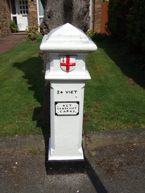
English: Coal Tax Pillar. This, I believe (from looking at other Geographs) is a Coal Tax Pillar, marking the boundary of the London Coal Tax area where a levy had to be paid if coal passed this point. Cf. 22931
24 VICT probably indicates that it was erected in the 24th year of Queen Victoria's reign, i.e. 1861 |
| Date | |
| Source | From geograph.org.uk |
| Author | Rob Farrow |
| Attribution (required by the license) | Rob Farrow / Coal Tax Pillar / |
| Object location | | View this and other nearby images on: OpenStreetMap |
|---|
_&language=en)
Licensing

|
This image was taken from the Geograph project collection. See this photograph's page on the Geograph website for the photographer's contact details. The copyright on this image is owned by Rob Farrow and is licensed for reuse under the Creative Commons Attribution-ShareAlike 2.0 license.
|
This file is licensed under the Creative Commons Attribution-Share Alike 2.0 Generic license.
Attribution: Rob Farrow
- You are free:
- to share – to copy, distribute and transmit the work
- to remix – to adapt the work
- Under the following conditions:
- attribution – You must give appropriate credit, provide a link to the license, and indicate if changes were made. You may do so in any reasonable manner, but not in any way that suggests the licensor endorses you or your use.
- share alike – If you remix, transform, or build upon the material, you must distribute your contributions under the same or compatible license as the original.
File history
Click on a date/time to view the file as it appeared at that time.
| Date/Time | Thumbnail | Dimensions | User | Comment | |
|---|---|---|---|---|---|
| current | 07:08, 31 January 2010 | | 480 × 640 (92 KB) | GeographBot | == {{int:filedesc}} == {{Information |description={{en|1=Coal Tax Pillar This, I believe (from looking at other Geographs) is a Coal Tax Pillar, marking the boundary of the London Coal Tax area where a levy had to be paid if coal passed this point. Cf. [[ |
File usage
The following pages on the English Wikipedia use this file (pages on other projects are not listed):
Global file usage
The following other wikis use this file:
- Usage on www.wikidata.org