
File:Castles of Munster, Dromore, Clare - geograph.org.uk - 1542601.jpg

Size of this preview: 800 × 538 pixels. Other resolutions: 320 × 215 pixels | 640 × 431 pixels | 1,024 × 689 pixels.
Original file (1,024 × 689 pixels, file size: 1.02 MB, MIME type: image/jpeg)
| This is a file from the Wikimedia Commons. Information from its description page there is shown below. Commons is a freely licensed media file repository. You can help. |
Summary
| Description |
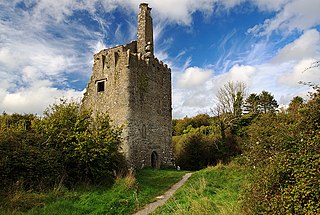
English: Castles of Munster: Dromore, Clare The castle is easy to find being signposted from the car park of a 400 hectare nature reserve and sited on the edge of a reed fringed inlet of Dromore Lough. The NE wall contains two levels of rooms above an entrance passage and guard room. There is a tall chimneystack at the top with corbels for a bartizan on the east corner. The stack would suggest a date of around 1600 for the castle's construction, confirmed by the inscription over the entrance recording its erection by the third earl of Thomond's second son Teige O'Brien, and his wife Slaney. |
| Date | |
| Source | From geograph.org.uk |
| Author | Mike Searle |
| Attribution (required by the license) | Mike Searle / Castles of Munster: Dromore, Clare / |
| Camera location | | View this and other nearby images on: OpenStreetMap |
|---|
_heading:315.00&language=en)
| Object location | | View this and other nearby images on: OpenStreetMap |
|---|
_heading:315.00&language=en)
Licensing

|
This image was taken from the Geograph project collection. See this photograph's page on the Geograph website for the photographer's contact details. The copyright on this image is owned by Mike Searle and is licensed for reuse under the Creative Commons Attribution-ShareAlike 2.0 license.
|
This file is licensed under the Creative Commons Attribution-Share Alike 2.0 Generic license.
Attribution: Mike Searle
- You are free:
- to share – to copy, distribute and transmit the work
- to remix – to adapt the work
- Under the following conditions:
- attribution – You must give appropriate credit, provide a link to the license, and indicate if changes were made. You may do so in any reasonable manner, but not in any way that suggests the licensor endorses you or your use.
- share alike – If you remix, transform, or build upon the material, you must distribute your contributions under the same or compatible license as the original.
File history
Click on a date/time to view the file as it appeared at that time.
| Date/Time | Thumbnail | Dimensions | User | Comment | |
|---|---|---|---|---|---|
| current | 07:03, 3 February 2019 | | 1,024 × 689 (1.02 MB) | Geograph Update Bot | Higher-resolution version from Geograph. |
| 09:21, 3 March 2011 |  | 640 × 430 (369 KB) | GeographBot | == {{int:filedesc}} == {{Information |description={{en|1=Castles of Munster: Dromore, Clare The castle is easy to find being signposted from the car park of a 400 hectare nature reserve and sited on the edge of a reed fringed inlet of Dromore Lough. The N |
File usage
The following pages on the English Wikipedia use this file (pages on other projects are not listed):
Global file usage
The following other wikis use this file:
- Usage on de.wikipedia.org
- Usage on ja.wikipedia.org
- Usage on ru.wikipedia.org
- Usage on uk.wikipedia.org
- Usage on www.wikidata.org