
File:Canadian weather radar network.png
No higher resolution available.
Canadian_weather_radar_network.png (550 × 210 pixels, file size: 96 KB, MIME type: image/png)
| This is a file from the Wikimedia Commons. Information from its description page there is shown below. Commons is a freely licensed media file repository. You can help. |
Summary
| Description |
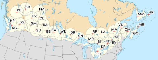
English: Radar positions and Identifiers at they will be at the beginning of 2023. 5 letters ID have been shorten for brevity, prepend "CAS" to recover the full ID. Radar ID and locations are from https://collaboration.cmc.ec.gc.ca/cmc/cmos/public_doc/msc-data/obs_radar/radars_list.pdf as of 2022-09-22. Coast, Lakes, Island, Borders are from GSHHG Intermediate resolution. Font are Hamlin, Projection is Canada Atlas Lambert, Color scheme is from https://en.wikipedia.org/wiki/Wikipedia:WikiProject_Maps/Conventions/Location_maps.
Français : Positions et identifiants des radars météorologiques canadiens tel qu'ils seront au début de 2023. Les ID des nouveaux radars depuis 2018 ont 5 lettres coupés à 2 sur l'image pour plus de concision : il suffit d'ajouter "CAS" devant l'ID pour récupérer l'identification complète. L'emplacement des radars provient de ce document mis à jour le 2022-09-22. |
| Date | |
| Source | Own work |
| Author | Pascal Normand |
Licensing
I, the copyright holder of this work, hereby publish it under the following license:
| This file is made available under the Creative Commons CC0 1.0 Universal Public Domain Dedication. | |
| The person who associated a work with this deed has dedicated the work to the public domain by waiving all of their rights to the work worldwide under copyright law, including all related and neighboring rights, to the extent allowed by law. You can copy, modify, distribute and perform the work, even for commercial purposes, all without asking permission.
|
File history
Click on a date/time to view the file as it appeared at that time.
| Date/Time | Thumbnail | Dimensions | User | Comment | |
|---|---|---|---|---|---|
| current | 20:14, 31 October 2022 | 550 × 210 (96 KB) | Norm6669 | We got to chose.... CASMM & CASFM... versus XNI and WMB. With CASMM online today, the new image start to be better. | |
| 17:15, 22 September 2022 | 550 × 210 (98 KB) | Norm6669 | Reverted to the current status of the network, we should reinstate the new version once the new radar are operational. | ||
| 17:12, 22 September 2022 | 550 × 210 (96 KB) | Norm6669 | Prepared for the new radar, will probably revert back to the old 2021/2022 version for a month or two. | ||
| 16:54, 21 January 2022 | 550 × 210 (98 KB) | Norm6669 | As suggested by Pierre CB, removed legend (notes?) to make it language independent, for the french and spanish wikis. | ||
| 17:01, 20 January 2022 | 550 × 210 (101 KB) | Norm6669 | Updated after the summer 2021 upgrades. CASCV should be up next monday (Jan 24th, as published in the genot). | ||
| 19:13, 10 April 2021 | 550 × 210 (102 KB) | Norm6669 | Radar range is lighter, color based too now, instead of just a big black line. This make WBI and XFT more readable. | ||
| 16:47, 10 April 2021 | 550 × 210 (112 KB) | Norm6669 | Uploaded own work with UploadWizard |
File usage
The following pages on the English Wikipedia use this file (pages on other projects are not listed):
Global file usage
The following other wikis use this file:
- Usage on es.wikipedia.org
- Usage on fr.wikipedia.org
- Usage on www.wikidata.org