
File:BroutinMargotCloseup.jpeg

Original file (1,198 × 745 pixels, file size: 297 KB, MIME type: image/jpeg)
| This is a file from the Wikimedia Commons. Information from its description page there is shown below. Commons is a freely licensed media file repository. You can help. |
Summary
| Description |
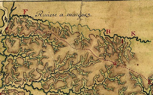
The watershed of the Riviere a Margot (now called Wolf River) in 1740. Everything above the red dotted line (a Chickasaw trail) is part of the Wolf River. Detail from the map Carte particulière d'une partie de la Louisianne ou les fleuve et rivierres onts etés relevé a l'estime & les routtes par terre relevé & mesurées aux pas, par les Srs. Broutin, de Vergés, ingénieurs & Saucier dessinateur. Drawn by a cartographer who only signed the name "Demarigny," the map concentrates on the surveys of Broutin, Vergés, and Saucier in Mississippi and Alabama. "Demarigny" was probably Antoine Phillipe, Sieur de Marigny, Chevalier de St. Louis (1722-1779), a New Orleans-based geographer and explorer. Whether or not the composite map was drawn by Antoine Phillipe, this specific map detail is based on surveys by his step-father, Ignace François Broutin, Capitaine Ingénieur du Roi [chief engineer of the Louisiana colony] during the Chickasaw Campaign of 1739-40. Broutin accompanied Jean-Baptiste Le Moyne, Sieur de Bienville, governor of Louisiana, up the Mississippi River on this military expedition and was charged with building fortifications (Forte d e l'Assumption on the Fourth Chickasaw Bluff at the mouth of the Margot River) and finding a way to move heavy siege weapons from Fort Assumption to, Ackia, the Chickasaw stronghold near present-day Pontotoc, Mississippi. A cannon-less Bienville suffered a bloody defeat at Ackia in 1736. Existing trails proved unsuitable for heavy wagons, so Broutin explored a water-route via the Margot (now the Wolf River) after a small group of young Iroquois mercenaries reported for duty at Ft. Assumption via the Margot, claiming that one of the river's branches extended to within 8 leagues of the Chickasaw villages. Broutin's party of French grenadiers and African slaves attempted the survey during the Wolf River Watershed's low water season (February) and encountered too many fallen trees snagging the channel. Before spring rains could raise the water level, Bienville secured a peace settlement with the Chickasaw and returned to New Orleans. The other watersheds depicted on this map detail, moving north to south, include Nonconnah Creek and the intricate Coldwater River system. A branch of the Little Tallahatchie is seen at the lower right corner, although it is identified by Broutin as the Riviere des Yasoax (Yazoo). The Little Tallahatchie does, however, flow into the Yazoo much further south. |
| Date | |
| Source | Library of Congress (the original chart was purchased during "personal visit to the foreign markets" by Philip Lee Phillips, Chief, Division of Maps and Charts, ca. 1905-06). Full map viewable at http://memory.loc.gov/cgi-bin/query/h?ammem/gmd:@field(NUMBER+@band(g4010+ct000681)) |
| Author | "Demarigny" (probably Antoine Phillipe de Marigny) and Ignace François Broutin |
Caption information sources
- Environmental Protection Agency, Office of Wetlands, Oceans and Watersheds, "Surf Your Watershed" site
- Journal of the Chickasa War by an unidentified French officer [1739-1740], published in Mississippi, as a Province, Territory and State, John Claiborne, 1880, pp. 82-83
- Basis for identifying the cartographer "Demarigny": Creole Families of New Orleans, Grace King, 1922, pp. 13-16
- Report of the Librarian of Congress 1906, pp. 43-44.
- The River Conservancy
Licensing
|
This is a faithful photographic reproduction of a two-dimensional, public domain work of art. The work of art itself is in the public domain for the following reason:
The official position taken by the Wikimedia Foundation is that "faithful reproductions of two-dimensional public domain works of art are public domain".
This photographic reproduction is therefore also considered to be in the public domain in the United States. In other jurisdictions, re-use of this content may be restricted; see Reuse of PD-Art photographs for details. | ||||
File history
Click on a date/time to view the file as it appeared at that time.
| Date/Time | Thumbnail | Dimensions | User | Comment | |
|---|---|---|---|---|---|
| current | 18:29, 7 April 2007 | | 1,198 × 745 (297 KB) | Bridgman | {{Information |Description= Map depicting Riviere a Margot (now called Wolf River). Detail from 'Carte particulière d'une partie de la Louisianne ou les fleuve et rivierres [i.e. rivières] onts etés relevé a l'estime & les routtes [i.e. routes] par t |
File usage
Global file usage
The following other wikis use this file:
- Usage on fr.wikipedia.org