
File:Brinsley Headstocks - geograph.org.uk - 46220.jpg
No higher resolution available.
Brinsley_Headstocks_-_geograph.org.uk_-_46220.jpg (640 × 480 pixels, file size: 69 KB, MIME type: image/jpeg)
| This is a file from the Wikimedia Commons. Information from its description page there is shown below. Commons is a freely licensed media file repository. You can help. |
Summary
| Description |
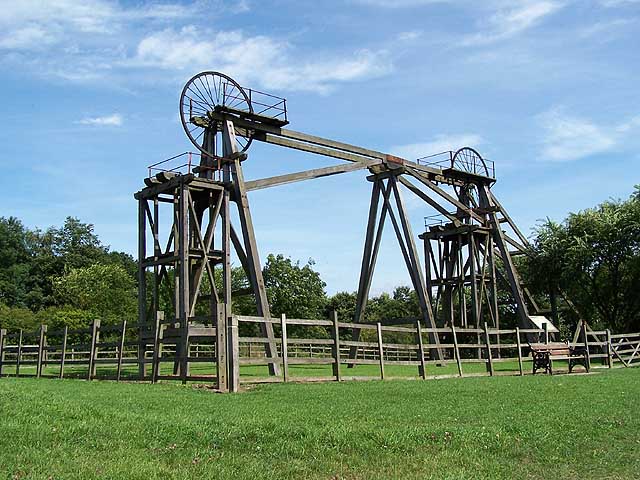
English: Brinsley Headstocks. Coal from the original shaft at Brinsley Colliery had almost been exhausted by the 1870s. A second deeper shaft was sunk in 1872 when tandem headstocks were erected but the reserves were once again exhausted by 1930. The shafts were kept open for another 40 years to provide access to neighbouring pits. The headstocks that now stand on the original site in Brinsley are the original structures of 1872, having been restored by British Coal and Nottinghamshire County Council in 1991. |
| Date | |
| Source | From geograph.org.uk |
| Author | Garth Newton |
| Attribution (required by the license) | Garth Newton / Brinsley Headstocks / |
| Camera location | | View this and other nearby images on: OpenStreetMap |
|---|
_heading:112.00&language=en)
| Object location | | View this and other nearby images on: OpenStreetMap |
|---|
_heading:112.00&language=en)
Licensing

|
This image was taken from the Geograph project collection. See this photograph's page on the Geograph website for the photographer's contact details. The copyright on this image is owned by Garth Newton and is licensed for reuse under the Creative Commons Attribution-ShareAlike 2.0 license.
|
This file is licensed under the Creative Commons Attribution-Share Alike 2.0 Generic license.
Attribution: Garth Newton
- You are free:
- to share – to copy, distribute and transmit the work
- to remix – to adapt the work
- Under the following conditions:
- attribution – You must give appropriate credit, provide a link to the license, and indicate if changes were made. You may do so in any reasonable manner, but not in any way that suggests the licensor endorses you or your use.
- share alike – If you remix, transform, or build upon the material, you must distribute your contributions under the same or compatible license as the original.
- Remove redundant categories and try to put this image in the most specific category/categories
- Remove this template
- The location categories are based on information from this geonames tool and this OpenStreetMap tool combined with a database. You can also have a look at this tool from mysociety.
- The topic category from Geograph was Industrial heritage (find similar images heritage at Geograph)
File history
Click on a date/time to view the file as it appeared at that time.
| Date/Time | Thumbnail | Dimensions | User | Comment | |
|---|---|---|---|---|---|
| current | 13:16, 30 January 2010 | | 640 × 480 (69 KB) | GeographBot | == {{int:filedesc}} == {{Information |description={{en|1=Brinsley Headstocks. Coal from the original shaft at Brinsley Colliery had almost been exhausted by the 1870s. A second deeper shaft was sunk in 1872 when tandem headstocks were erected but the res |
File usage
The following pages on the English Wikipedia use this file (pages on other projects are not listed):
Global file usage
The following other wikis use this file:
- Usage on www.wikidata.org