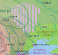
File:Bolohoveni land from A.V. Boldur description.PNG
Bolohoveni_land_from_A.V._Boldur_description.PNG (278 × 267 pixels, file size: 115 KB, MIME type: image/png)
File history
Click on a date/time to view the file as it appeared at that time.
| Date/Time | Thumbnail | Dimensions | User | Comment | |
|---|---|---|---|---|---|
| current | 03:00, 17 September 2021 |  | 278 × 267 (115 KB) | Trecătorul răcit | Left the cities, remove their hypothetic borders |
| 18:25, 13 July 2016 |  | 278 × 267 (115 KB) | Julieta39 | More colours, Cumans & later Tatars | |
| 20:42, 30 March 2014 |  | 278 × 267 (112 KB) | Spiridon Ion Cepleanu | More details according with Nicolae Iorga & Alexandru Boldur | |
| 06:30, 8 May 2013 |  | 278 × 320 (116 KB) | Eurocentral | {{subst:Upload marker added by en.wp UW}} {{Information |Description = {{en|a map of a historical region, between Nistru and Nipru rivers, Northern Black Sea.}} |Source = in May 7, 2013, only for Wiki pages<br/> '''Previously published:''' only for Wik... |
File usage
The following pages on the English Wikipedia use this file (pages on other projects are not listed):
Global file usage
The following other wikis use this file:
- Usage on ro.wikipedia.org
- Usage on ru.wikipedia.org
- Usage on sl.wikipedia.org
- Usage on sr.wikipedia.org
- Usage on uk.wikipedia.org
- Usage on www.wikidata.org
