
File:Bodies on the battlefield at antietam.jpg

Size of this preview: 800 × 560 pixels. Other resolutions: 320 × 224 pixels | 640 × 448 pixels | 1,024 × 717 pixels | 1,280 × 897 pixels | 2,560 × 1,793 pixels | 6,202 × 4,344 pixels.
Original file (6,202 × 4,344 pixels, file size: 5.89 MB, MIME type: image/jpeg)
| This is a file from the Wikimedia Commons. Information from its description page there is shown below. Commons is a freely licensed media file repository. You can help. |
Summary
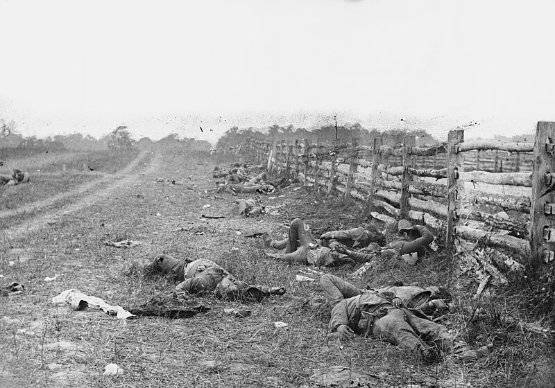
| Alexander Gardner: Bodies on the battlefield at Antietam
|
||||||||||||||||||||||||||||
|---|---|---|---|---|---|---|---|---|---|---|---|---|---|---|---|---|---|---|---|---|---|---|---|---|---|---|---|---|
| Photographer |
|
 | ||||||||||||||||||||||||||
| Title |
The Dead of Antietam |
|||||||||||||||||||||||||||
| Object type |
photograph |
|||||||||||||||||||||||||||
| Genre |
photojournalism |
|||||||||||||||||||||||||||
| Description |
Photograph of the field at Antietam, American Civil War. Confederate dead by a fence at the Hagerstown Turnpike, looking north; the Turnpike is to the right of the fence, the dirt lane on the left leads to the farm of David Miller. |
|||||||||||||||||||||||||||
| Date | Taken in September 1862 | |||||||||||||||||||||||||||
| References |
100 Photographs: The Most Influential Images of All Time |
|||||||||||||||||||||||||||
| Source |
|
|||||||||||||||||||||||||||
| Permission (Reusing this file) |
Public domain | |||||||||||||||||||||||||||


| Camera location | | View this and other nearby images on: OpenStreetMap |
|---|
Licensing
|
This work is in the public domain in its country of origin and other countries and areas where the copyright term is the author's life plus 100 years or fewer. This work is in the public domain in the United States because it was published (or registered with the U.S. Copyright Office) before January 1, 1929. | |
| This file has been identified as being free of known restrictions under copyright law, including all related and neighboring rights. | |
File history
Click on a date/time to view the file as it appeared at that time.
| Date/Time | Thumbnail | Dimensions | User | Comment | |
|---|---|---|---|---|---|
| current | 22:29, 12 August 2013 | | 6,202 × 4,344 (5.89 MB) | Ras67 | high resolution |
| 22:36, 13 May 2011 |  | 838 × 587 (104 KB) | Cropbot | upload cropped version, operated by User:Beao. Summary: cropped away burned edges | |
| 15:47, 11 August 2005 |  | 971 × 728 (135 KB) | Shauni | Photograph of the field at Antietam, American Civil War. From the Library of Congress' American Memory collection ORIGINAL LOCATION: http://memory.loc.gov/ndlpcoop/nhnycw/ad/ad18/ad18045v.jpg {{PD}} Category:American Civil War |
File usage
The following pages on the English Wikipedia use this file (pages on other projects are not listed):
- 2nd Louisiana Infantry Regiment (Confederate)
- Alexander Gardner (photographer)
- Battle of Antietam
- History of Maryland
- List of photographs considered the most important
- Maryland in the American Civil War
- Military history of the United States
- Timeline of United States history (1860–1899)
- War photography
- User:Howardcorn33/sandbox/List of photographs considered the most important
- User:Snowmanonahoe/List of photographs considered the most important
Global file usage
The following other wikis use this file:
- Usage on ar.wikipedia.org
- Usage on ast.wikipedia.org
- Usage on azb.wikipedia.org
- Usage on az.wikipedia.org
- Usage on ca.wikipedia.org
- Usage on co.wikipedia.org
- Usage on cs.wikipedia.org
- Usage on da.wikipedia.org
- Usage on de.wikipedia.org
- Usage on en.wikiquote.org
- Usage on eo.wikipedia.org
- Usage on es.wikipedia.org
- Usage on fa.wikipedia.org
- Usage on fy.wikipedia.org
- Usage on he.wikipedia.org
- Usage on hy.wikipedia.org
- Usage on id.wikipedia.org
- Usage on incubator.wikimedia.org
- Usage on it.wikipedia.org
- Usage on ja.wikipedia.org
- Usage on km.wikipedia.org
- Usage on ko.wikipedia.org
- Usage on la.wikipedia.org
- Usage on ms.wikipedia.org
- Usage on nl.wikipedia.org
- Usage on no.wikipedia.org
- Usage on pl.wikipedia.org
View more global usage of this file.