
File:Betws Bledrws - geograph.org.uk - 755570.jpg
No higher resolution available.
Betws_Bledrws_-_geograph.org.uk_-_755570.jpg (640 × 480 pixels, file size: 75 KB, MIME type: image/jpeg)
| This is a file from the Wikimedia Commons. Information from its description page there is shown below. Commons is a freely licensed media file repository. You can help. |
Summary
| Description |
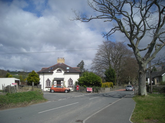
English: Betws Bledrws The small village of Betws Bledrws lies three miles from Lampeter on either side of the A485. It comprises two parts: Bro Deri, a row of council houses in the north of square SN5951 and the village proper shown here.
The white building is New Lodge, built in c.1840 to the design of Charles Cockerell, who also designed the house whose gate it guarded, Derry Ormond Park (demolished in 1953). Cockerell was also responsible for the designs of St. David's College (now the University of Wales, Lampeter) and Derry Ormond Tower. |
| Date | |
| Source | From geograph.org.uk |
| Author | Dan Gregory |
| Attribution (required by the license) | Dan Gregory / Betws Bledrws / |
| Camera location | | View this and other nearby images on: OpenStreetMap |
|---|
_heading:45.00&language=en)
| Object location | | View this and other nearby images on: OpenStreetMap |
|---|
_heading:45.00&language=en)
Licensing

|
This image was taken from the Geograph project collection. See this photograph's page on the Geograph website for the photographer's contact details. The copyright on this image is owned by Dan Gregory and is licensed for reuse under the Creative Commons Attribution-ShareAlike 2.0 license.
|
This file is licensed under the Creative Commons Attribution-Share Alike 2.0 Generic license.
Attribution: Dan Gregory
- You are free:
- to share – to copy, distribute and transmit the work
- to remix – to adapt the work
- Under the following conditions:
- attribution – You must give appropriate credit, provide a link to the license, and indicate if changes were made. You may do so in any reasonable manner, but not in any way that suggests the licensor endorses you or your use.
- share alike – If you remix, transform, or build upon the material, you must distribute your contributions under the same or compatible license as the original.
File history
Click on a date/time to view the file as it appeared at that time.
| Date/Time | Thumbnail | Dimensions | User | Comment | |
|---|---|---|---|---|---|
| current | 14:18, 19 February 2011 | | 640 × 480 (75 KB) | GeographBot | == {{int:filedesc}} == {{Information |description={{en|1=Betws Bledrws The small village of Betws Bledrws lies three miles from Lampeter on either side of the A485. It comprises two parts: Bro Deri, a row of council houses in the north of square [[SN5951] |
File usage
The following pages on the English Wikipedia use this file (pages on other projects are not listed):
Global file usage
The following other wikis use this file:
- Usage on cy.wikipedia.org
- Usage on www.wikidata.org