
File:Arup-SUM tracé.jpg

Size of this preview: 755 × 600 pixels. Other resolutions: 302 × 240 pixels | 605 × 480 pixels | 1,001 × 795 pixels.
Original file (1,001 × 795 pixels, file size: 1.13 MB, MIME type: image/jpeg)
| This is a file from the Wikimedia Commons. Information from its description page there is shown below. Commons is a freely licensed media file repository. You can help. |
Summary
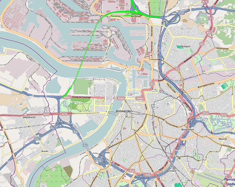
| Description | Oosterweelverbinding: Schema van het boortunneltracé ontwikkeld door Arup/SUM in juli 2009 in opdracht van de stad Antwerpen. |
| Date | |
| Source | Own work |
| Author | open source, diverse contributors to the map |
Licensing
| I, the copyright holder of this work, release this work into the public domain. This applies worldwide. In some countries this may not be legally possible; if so: I grant anyone the right to use this work for any purpose, without any conditions, unless such conditions are required by law. |
File history
Click on a date/time to view the file as it appeared at that time.
| Date/Time | Thumbnail | Dimensions | User | Comment | |
|---|---|---|---|---|---|
| current | 07:41, 29 October 2009 | | 1,001 × 795 (1.13 MB) | Limehome | {{Information |Description={{nl|1=Schema van het boortunneltracé ontwikkeld door Arup/SUM in juli 2009 in opdracht van de stad Antwerpen.}} |Source={{own}} |Author=Limehome |Date=2009-10-25 |Permission= |other_versions= }} |
File usage
The following pages on the English Wikipedia use this file (pages on other projects are not listed):
Global file usage
The following other wikis use this file:
- Usage on nl.wikipedia.org