
File:Arlbergbahn.png
Size of this preview: 800 × 297 pixels. Other resolutions: 320 × 119 pixels | 640 × 238 pixels | 1,024 × 381 pixels | 1,280 × 476 pixels | 2,809 × 1,044 pixels.
Original file (2,809 × 1,044 pixels, file size: 2.27 MB, MIME type: image/png)
| This is a file from the Wikimedia Commons. Information from its description page there is shown below. Commons is a freely licensed media file repository. You can help. |
Summary
| Description |
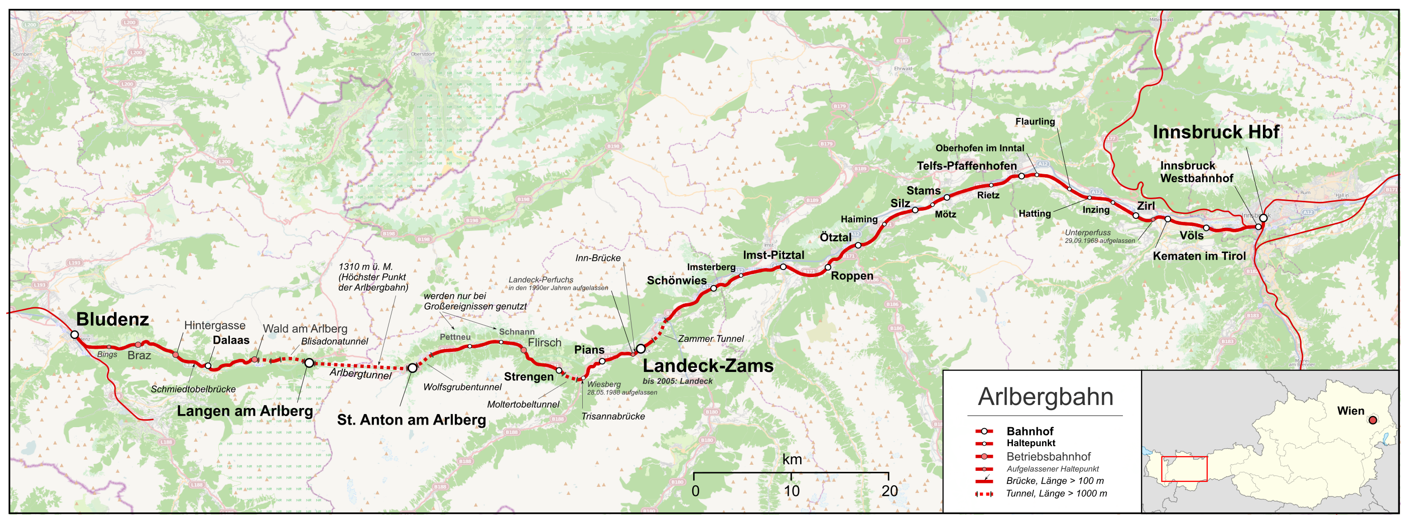
English: Map of Arlberg Railway from Bludenz to St. Anton am Arlberg, Landeck (Tirol) and in the East Innsbruck.
Deutsch: Karte der Arlbergbahn, eine Ost-West-Eisenbahnlinie in den Alpen von Bludenz und einigen Zwischenstationen durch den Arlberg-Tunnel nach St. Anton am Arlberg und ohne Anschluss an eine Nord-Süd-Alpentransversale über einige Stationen weiter nach Landeck (Tirol) und nach Innsbruck. |
| Date | |
| Source |
Map was created using:
|
| Author | |
| Permission (Reusing this file) |
Map data (c) OpenStreetMap (and) contributors, CC-BY-SA |
Licensing
This file is licensed under the Creative Commons Attribution-Share Alike 2.0 Generic license.
- You are free:
- to share – to copy, distribute and transmit the work
- to remix – to adapt the work
- Under the following conditions:
- attribution – You must give appropriate credit, provide a link to the license, and indicate if changes were made. You may do so in any reasonable manner, but not in any way that suggests the licensor endorses you or your use.
- share alike – If you remix, transform, or build upon the material, you must distribute your contributions under the same or compatible license as the original.
File history
Click on a date/time to view the file as it appeared at that time.
| Date/Time | Thumbnail | Dimensions | User | Comment | |
|---|---|---|---|---|---|
| current | 14:33, 27 November 2021 | 2,809 × 1,044 (2.27 MB) | Pechristener | Lage der Schmiedtobelbrücke korrigiert | |
| 07:37, 10 August 2013 | 2,996 × 1,114 (2.19 MB) | Pechristener | Betriebsbahnhöfe ausgewiesen, Unterscheidung zwischen Bahnhöfen und Haltepunkten hinzu, Legende hinzu, Anmerkung bzgl eingetragener Brücken und Tunnel hinzu | ||
| 14:11, 9 August 2013 | 2,996 × 1,114 (2.15 MB) | Pechristener | Wolfgrubentunnel richtig bezeichnet Dritter Tunnel zwischen Blisadonatunnel und Wildentobeltunnel entfernt | ||
| 18:12, 8 August 2013 | 2,996 × 1,114 (2.15 MB) | Pechristener | Pludenz >> Bludenz | ||
| 20:36, 7 August 2013 | 2,956 × 1,074 (2.25 MB) | Pechristener | Verbessert: grössere Schrift, Rahmen, Massstab, Locater Map etc. | ||
| 22:07, 6 August 2013 | 3,039 × 1,143 (2.35 MB) | Pechristener | == {{int:filedesc}} == {{Information |Description ={{en|1=Map of Arlberg Railway}} {{de|1=Karte der Arlbergbahn }} |Source ={{own}} Map was created using: *[http://www.openstreetmap.org/?lat=4... |
File usage
The following pages on the English Wikipedia use this file (pages on other projects are not listed):
Global file usage
The following other wikis use this file:
- Usage on de.wikipedia.org
- Usage on fr.wikipedia.org
- Usage on hu.wikipedia.org
- Usage on it.wikipedia.org
- Usage on ja.wikipedia.org
- Usage on nl.wikipedia.org
- Usage on www.wikidata.org