
File:Appalachia Williams.png
No higher resolution available.
Appalachia_Williams.png (444 × 474 pixels, file size: 34 KB, MIME type: image/png)
| This is a file from the Wikimedia Commons. Information from its description page there is shown below. Commons is a freely licensed media file repository. You can help. |
Summary
| Description |
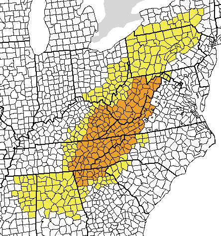
English: "Appalachia" |
| Date | |
| Source | I created this map, using a blank map from the Wiki Commons (Image:Map of USA with county outlines (black & white).png) and painting the counties defined as "Appalachia" by the Appalachia Regional Commission in yellow and the "core" region, as defined in the book "Appalachia: A History" by John Alexander Williams, in orange. |
| Author | Pfly (talk) (Uploads) |
.png)
Licensing
I, the copyright holder of this work, hereby publish it under the following licenses:
| This file is licensed under the Creative Commons Attribution-Share Alike 3.0 Unported license. Subject to disclaimers. | ||
| ||
| This licensing tag was added to this file as part of the GFDL licensing update. |

|
Permission is granted to copy, distribute and/or modify this document under the terms of the GNU Free Documentation License, Version 1.2 or any later version published by the Free Software Foundation; with no Invariant Sections, no Front-Cover Texts, and no Back-Cover Texts. A copy of the license is included in the section entitled GNU Free Documentation License. Subject to disclaimers. |
This file is licensed under the Creative Commons Attribution 2.5 Generic license.
- You are free:
- to share – to copy, distribute and transmit the work
- to remix – to adapt the work
- Under the following conditions:
- attribution – You must give appropriate credit, provide a link to the license, and indicate if changes were made. You may do so in any reasonable manner, but not in any way that suggests the licensor endorses you or your use.
You may select the license of your choice.
File history
Click on a date/time to view the file as it appeared at that time.
| Date/Time | Thumbnail | Dimensions | User | Comment | |
|---|---|---|---|---|---|
| current | 03:52, 11 February 2007 | | 444 × 474 (34 KB) | Pfly | I created this map, using a blank map from the Wiki Commons (Image:Map of USA with county outlines (black & white).png) and painting the counties defined as "Appalachia" by the Appalachia Regional Commission in yellow and the "core" region, as defined in |
File usage
The following pages on the English Wikipedia use this file (pages on other projects are not listed):