
File:Angles, Saxons, Jutes in Britain year 600.jpg

Original file (1,126 × 810 pixels, file size: 301 KB, MIME type: image/jpeg)
| This is a file from the Wikimedia Commons. Information from its description page there is shown below. Commons is a freely licensed media file repository. You can help. |
Original Sumario
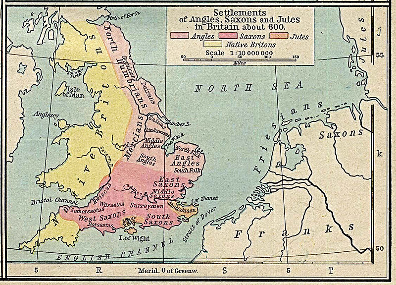
es: Mapa de Gran Bretaña en el año 600, con la correspondiente distribución de los pueblos Anglos, Sajones y Jutos.
Autorización del autor: Unless marked otherwise, the maps scanned by the University of Texas Libraries are in the public domain. The map images are not copyrighted and no permission is needed to copy them. You may download them and use them as you wish.
We do appreciate hearing from you about your use of these materials and we also appreciate you giving this site credit. Appropriate credit for public domain materials would be: "Courtesy of the University of Texas Libraries, The University of Texas at Austin."
For more information, see The PCL Map Collection Frequently Asked Questions page at http://www.lib.utexas.edu/maps/faq.html or feel free to contact me. __ Becky Schaefer Digital Library Services Division University of Texas Libraries
rschaefer@austin.utexas.edu
Licensing, updated
|
This work is in the public domain in its country of origin and other countries and areas where the copyright term is the author's life plus 70 years or fewer.
| |
| This file has been identified as being free of known restrictions under copyright law, including all related and neighboring rights. | |
File history
Click on a date/time to view the file as it appeared at that time.
| Date/Time | Thumbnail | Dimensions | User | Comment | |
|---|---|---|---|---|---|
| current | 18:21, 17 April 2013 | | 1,126 × 810 (301 KB) | Hohum | Levels |
| 17:26, 18 April 2006 |  | 1,126 × 810 (230 KB) | Alexquendi~commonswiki | es: Mapa de Gran Bretaña en el año 600, con la correspondiente distribución de los pueblos Anglos, Sajones y Jutos. Autorización del autor: Unless marked otherwise, the maps scanned by the University of Texas Libraries are in the public domain. The m |
File usage
Global file usage
The following other wikis use this file:
- Usage on arz.wikipedia.org
- Usage on ast.wikipedia.org
- Usage on br.wikipedia.org
- Usage on ca.wikipedia.org
- Usage on de.wikipedia.org
- Usage on es.wikipedia.org
- Usage on he.wikipedia.org
- Usage on it.wikipedia.org
- Usage on nl.wikipedia.org
- Usage on sv.wikipedia.org
- Usage on uk.wikipedia.org
- Usage on vls.wikipedia.org