File:All Saints, Easton, floor memorial - geograph.org.uk - 2014746.jpg

Page contents not supported in other languages.
This is a file from the Wikimedia Commons
From Wikipedia, the free encyclopedia

Original file(480 × 640 pixels, file size: 83 KB, MIME type: image/jpeg)

Description
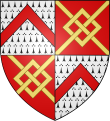
Arms of Tuchet, Earl of Castlehaven: Tuchet quartering Audley
Ledger stone to Dame Mary Touchet, who died aged 18 in 1675, wife of Sir Henry Wingfield, 4th Baronet (c. 1655 – 1677), of Easton, Suffolk, who died aged 22 having at the age of 16 succeeded his elder brother Sir Robert Wingfield, 3rd Baronet (c. 1652 – c. 1671). Sir Henry Wingfield (died 1677), while in Dulward, Lorraine serving the French army, had his leg shot off. (Lodge, John (1789). "Viscount POWERSCOURT". The Peerage of Ireland: Or, A Genealogical History of the Present Nobility of that Kingdom. V. J. Moore. p. 263[1]) Mary Touchet was a daughter of Mervyn Tuchet, 4th Earl of Castlehaven (died 1686). Arms: Wingfield (Argent, on a bend gules three wings conjoined in lure of the field), quarterly of four, impaling Touchet (Ermine, a chevron gules) quartering Audley (Gules, a fret or) overall an inescutcheon of a baronet (Red Hand of Ulster).
Date  Edit this at Structured Data on Commons
Source Geograph Britain and Ireland Edit this at Structured Data on Commons
Author Basher Eyre Edit this at Structured Data on Commons

Summary

Description
English: All Saints, Easton: floor memorial Edit this at Structured Data on Commons
Depicts
InfoField
memorial, Easton Edit this on Structured Data on Commons
Date  Edit this at Structured Data on Commons
Source Geograph Britain and Ireland Edit this at Structured Data on Commons
Author Basher Eyre Edit this at Structured Data on Commons
Place of creation
InfoField
Easton Edit this at Structured Data on Commons (EastonEast SuffolkSuffolkEast of EnglandEnglandUnited Kingdom)
Camera location52° 10′ 49.2″ N, 1° 20′ 18″ E Edit this at Structured Data on Commons  Heading=+270° Kartographer map based on OpenStreetMap.View this and other nearby images on: OpenStreetMapinfo
Object location52° 10′ 49.3″ N, 1° 20′ 17″ E Edit this at Structured Data on Commons Kartographer map based on OpenStreetMap.View this and other nearby images on: OpenStreetMapinfo

Licensing

w:en:Creative Commons
attribution share alike
This file is licensed under the Creative Commons Attribution-Share Alike 2.0 Generic license.
Attribution: All Saints, Easton: floor memorial by Basher Eyre
You are free:
  • to share – to copy, distribute and transmit the work
  • to remix – to adapt the work
Under the following conditions:
  • attribution – You must give appropriate credit, provide a link to the license, and indicate if changes were made. You may do so in any reasonable manner, but not in any way that suggests the licensor endorses you or your use.
  • share alike – If you remix, transform, or build upon the material, you must distribute your contributions under the same or compatible license as the original.

Captions

All Saints, Easton: floor memorial

Items portrayed in this file

depicts

13 August 2010

52°10'49.1"N, 1°20'18.2"E

heading: 270 degree

52°10'49.4"N, 1°20'16.4"E

image/jpeg

2fcc3f16e44f8230346420ad3817ca4d6885cd99

84,561 byte

640 pixel

480 pixel

File history

Click on a date/time to view the file as it appeared at that time.

Date/TimeThumbnailDimensionsUserComment
current20:27, 17 May 2021Thumbnail for version as of 20:27, 17 May 2021480 × 640 (83 KB)GeographBotUploading geograph.org.uk image from https://www.geograph.org.uk/photo/2014746
The following pages on the English Wikipedia use this file (pages on other projects are not listed):