
File:All Saints' Church - geograph.org.uk - 1715781.jpg

Size of this preview: 800 × 523 pixels. Other resolutions: 320 × 209 pixels | 640 × 418 pixels | 1,024 × 669 pixels | 1,280 × 837 pixels | 2,131 × 1,393 pixels.
Original file (2,131 × 1,393 pixels, file size: 3.21 MB, MIME type: image/jpeg)
| This is a file from the Wikimedia Commons. Information from its description page there is shown below. Commons is a freely licensed media file repository. You can help. |
Summary
| Description |
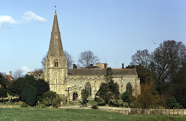
English: All Saints' Church
This photograph of All Saints' Church was taken from a footpath that links Old Hall Farm (behind the viewpoint) with (ahead, in front of the church). The church was the location for the wedding of the poet William Wordsworth who in 1802 married Mary Hutchinson, of nearby Gallows Hill. See also this photograph (2007) of the church: 426956. The data given for the date taken is the processing date on the slide and therefore could have been taken several weeks earlier. |
| Date | |
| Source | From geograph.org.uk |
| Author | Alan Walker |
| Attribution (required by the license) | Alan Walker / All Saints' Church / |
This is a photo of listed building number 1316111. |
| Camera location | | View this and other nearby images on: OpenStreetMap |
|---|
_heading:0.00&language=en)
| Object location | | View this and other nearby images on: OpenStreetMap |
|---|
_heading:0.00&language=en)
Licensing

|
This image was taken from the Geograph project collection. See this photograph's page on the Geograph website for the photographer's contact details. The copyright on this image is owned by Alan Walker and is licensed for reuse under the Creative Commons Attribution-ShareAlike 2.0 license.
|
This file is licensed under the Creative Commons Attribution-Share Alike 2.0 Generic license.
Attribution: Alan Walker
- You are free:
- to share – to copy, distribute and transmit the work
- to remix – to adapt the work
- Under the following conditions:
- attribution – You must give appropriate credit, provide a link to the license, and indicate if changes were made. You may do so in any reasonable manner, but not in any way that suggests the licensor endorses you or your use.
- share alike – If you remix, transform, or build upon the material, you must distribute your contributions under the same or compatible license as the original.
File history
Click on a date/time to view the file as it appeared at that time.
| Date/Time | Thumbnail | Dimensions | User | Comment | |
|---|---|---|---|---|---|
| current | 07:34, 5 March 2011 | | 2,131 × 1,393 (3.21 MB) | GeographBot | == {{int:filedesc}} == {{Information |description={{en|1=All Saints' Church This photograph of All Saints' Church was taken from a footpath that links Old Hall Farm (behind the viewpoint) with (ahead, in front of the church). The church was the lo |
File usage
The following pages on the English Wikipedia use this file (pages on other projects are not listed):
Global file usage
The following other wikis use this file:
- Usage on de.wikipedia.org
- Usage on www.wikidata.org