
File:Adpar and the county boundary - geograph.org.uk - 919887.jpg
No higher resolution available.
Adpar_and_the_county_boundary_-_geograph.org.uk_-_919887.jpg (640 × 480 pixels, file size: 81 KB, MIME type: image/jpeg)
| This is a file from the Wikimedia Commons. Information from its description page there is shown below. Commons is a freely licensed media file repository. You can help. |
Summary
| Description |
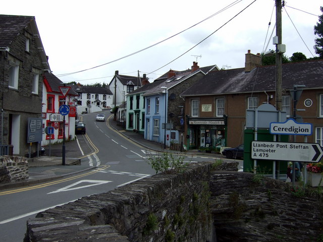
English: Adpar and the county boundary The river is the county boundary, Newcastle Emlyn to the south being in Sir Caerfyrddin and Adpar, seen here, in Sir Ceredigion.
This is an important river crossing where three roads converge: the A475 east from Llanbedr Pont Steffan and B roads from the north and west. Note the position of the letter box in the centre of the image, with a plaque beside it commemorating the site of Wales' first printing press. The house to the right of it was the Salutation Inn, scene of the quarrel that preceded the last duel fought in Wales, nearby, in 1814. See http://www.newcastleemlyn.info/page14.html |
| Date | |
| Source | From geograph.org.uk |
| Author | ceridwen |
| Attribution (required by the license) | ceridwen / Adpar and the county boundary / |
| Camera location | | View this and other nearby images on: OpenStreetMap |
|---|
_heading:0.00&language=en)
| Object location | | View this and other nearby images on: OpenStreetMap |
|---|
_heading:0.00&language=en)
Licensing

|
This image was taken from the Geograph project collection. See this photograph's page on the Geograph website for the photographer's contact details. The copyright on this image is owned by ceridwen and is licensed for reuse under the Creative Commons Attribution-ShareAlike 2.0 license.
|
This file is licensed under the Creative Commons Attribution-Share Alike 2.0 Generic license.
Attribution: ceridwen
- You are free:
- to share – to copy, distribute and transmit the work
- to remix – to adapt the work
- Under the following conditions:
- attribution – You must give appropriate credit, provide a link to the license, and indicate if changes were made. You may do so in any reasonable manner, but not in any way that suggests the licensor endorses you or your use.
- share alike – If you remix, transform, or build upon the material, you must distribute your contributions under the same or compatible license as the original.
File history
Click on a date/time to view the file as it appeared at that time.
| Date/Time | Thumbnail | Dimensions | User | Comment | |
|---|---|---|---|---|---|
| current | 22:11, 21 February 2011 | | 640 × 480 (81 KB) | GeographBot | == {{int:filedesc}} == {{Information |description={{en|1=Adpar and the county boundary The river is the county boundary, Newcastle Emlyn to the south being in Sir Caerfyrddin and Adpar, seen here, in Sir Ceredigion. This is an important river crossing wh |
File usage
The following pages on the English Wikipedia use this file (pages on other projects are not listed):
Global file usage
The following other wikis use this file: