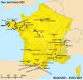
File:2021 Tour de France map.svg

Page contents not supported in other languages.
This is a file from the Wikimedia Commons
From Wikipedia, the free encyclopedia

Original file(SVG file, nominally 2,385 × 2,292 pixels, file size: 5.9 MB)

Summary

Description
Français : Carte du parcours du Tour de France 2021
English: Route map of the 2021 Tour de France
Español: Mapa del recorrido del Tour de Francia 2021
Deutsch: Streckenplan der Tour de France 2021
Italiano: Mappa del percorso del Tour de France 2021
中文:2021年环法自行车赛的路线图
Français :
Grand Départ
Arrivée finale
Départ étape
Arrivée étape
Parcours étape
Contre-la-montre individuel
English:
Race Start
Race Finish
Stage start
Stage finish
Stage route
Individual time-trial
Español:
Inicio de la carrera
Final de carrera
Inicio de la etapa
Final de la etapa
Recorrido de la etapa
Contrarreloj individual
Deutsch:
Start des Rennens
Ziel des Rennens
Etappenstart
Etappenziel
Etappen-Route
Einzelzeitfahren
Italiano:
Inizio della gara
Fine della gara
Inizio di tappa
Arrivo di tappa
Percorso della tappa
Prova a tempo individuale
中文:
本届环法起点
本届环法终点
分赛段起点
分赛段终点
分赛段路线
个人计时赛
Date
Source Own work
This file was derived from: Tour de France base map.svg
Author Tomchen1989

Licensing

w:en:Creative Commons
attribution share alike
This file is licensed under the Creative Commons Attribution-Share Alike 4.0 International license.
You are free:
  • to share – to copy, distribute and transmit the work
  • to remix – to adapt the work
Under the following conditions:
  • attribution – You must give appropriate credit, provide a link to the license, and indicate if changes were made. You may do so in any reasonable manner, but not in any way that suggests the licensor endorses you or your use.
  • share alike – If you remix, transform, or build upon the material, you must distribute your contributions under the same or compatible license as the original.

Captions

Route map of the 2021 Tour de France

Items portrayed in this file

depicts

28 June 2021

image/svg+xml

b98ccd6b3eb1ced41d96941cb8d3fd851f1147f9

6,181,848 byte

2,292 pixel

2,385 pixel

File history

Click on a date/time to view the file as it appeared at that time.

Date/TimeThumbnailDimensionsUserComment
current17:38, 1 July 2021Thumbnail for version as of 17:38, 1 July 20212,385 × 2,292 (5.9 MB)Tomchen1989Tours name fixed; text align adjustment for some
17:50, 30 June 2021Thumbnail for version as of 17:50, 30 June 20212,385 × 2,292 (5.9 MB)Tomchen1989Lorient name fixed, add Andorran towns' French names
11:55, 29 June 2021Thumbnail for version as of 11:55, 29 June 20212,385 × 2,292 (5.9 MB)Tomchen1989Done
21:13, 28 June 2021Thumbnail for version as of 21:13, 28 June 20212,385 × 2,292 (5.89 MB)Tomchen1989Uploaded own work with UploadWizard
The following pages on the English Wikipedia use this file (pages on other projects are not listed):

Global file usage

The following other wikis use this file:

Metadata