
File:20191123 Guyana 0228 Kyk Over Al Island sRGB (49295897097).jpg

Size of this preview: 800 × 533 pixels. Other resolutions: 320 × 213 pixels | 640 × 427 pixels | 1,024 × 683 pixels | 1,280 × 853 pixels | 2,560 × 1,707 pixels | 5,472 × 3,648 pixels.
Original file (5,472 × 3,648 pixels, file size: 6.57 MB, MIME type: image/jpeg)
| This is a file from the Wikimedia Commons. Information from its description page there is shown below. Commons is a freely licensed media file repository. You can help. |
.jpg)
Summary
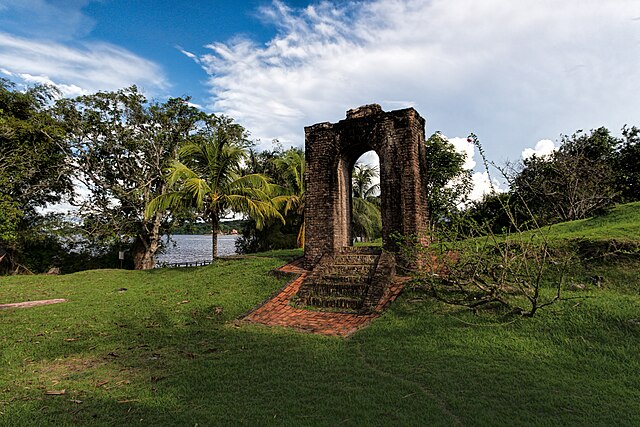
| Description | An entrance gate is all that remains of the small, star-shaped Fort Kyk-Over-Al that was built by the Dutch in 1616. Believed to be the smallest fort ever built by the Dutch, it was part of a trading post on a 1.5-acre island in the Mazaruni River where it’s met by the Cuyuni River just before joining the Essequibo River. Originally named Fort ter Hoogen after a Dutch businessman, it was soon renamed Kyk-Over-Al which comes from the Dutch for “see over all.” In 1665 the British occupied the fort but only briefly until the Dutch recaptured it. An attack by French privateers in 1708 was successfully repulsed as was an attack by a combined force of French and Spanish buccaneers in 1712. In 1739 the fort was abandoned to be superseded by the bigger Fort Zeelandia on a large island in the mouth of the Essequibo River. |
| Date | |
| Source | 20191123_Guyana_0228 Kyk Over Al Island sRGB |
| Author | Dan Lundberg |
| Camera location | | View this and other nearby images on: OpenStreetMap |
|---|
.jpg¶ms=006.378856_N_-058.688138_E_globe:Earth_type:camera_source:Flickr_&language=en)
Licensing
This file is licensed under the Creative Commons Attribution-Share Alike 2.0 Generic license.
- You are free:
- to share – to copy, distribute and transmit the work
- to remix – to adapt the work
- Under the following conditions:
- attribution – You must give appropriate credit, provide a link to the license, and indicate if changes were made. You may do so in any reasonable manner, but not in any way that suggests the licensor endorses you or your use.
- share alike – If you remix, transform, or build upon the material, you must distribute your contributions under the same or compatible license as the original.
| This image was originally posted to Flickr by Dan Lundberg at https://flickr.com/photos/9508280@N07/49295897097. It was reviewed on 21 May 2020 by FlickreviewR 2 and was confirmed to be licensed under the terms of the cc-by-sa-2.0. |
File history
Click on a date/time to view the file as it appeared at that time.
| Date/Time | Thumbnail | Dimensions | User | Comment | |
|---|---|---|---|---|---|
| current | 19:47, 21 May 2020 | | 5,472 × 3,648 (6.57 MB) | ZiaLater | Transferred from Flickr via #flickr2commons |
File usage
The following pages on the English Wikipedia use this file (pages on other projects are not listed):
Global file usage
The following other wikis use this file:
- Usage on be.wikipedia.org
- Usage on en.wikivoyage.org
- Usage on es.wikipedia.org
- Usage on hr.wikipedia.org
- Usage on it.wikivoyage.org
- Usage on mt.wikipedia.org
- Usage on nl.wikipedia.org
- Usage on ru.wikipedia.org
- Usage on sh.wikipedia.org
- Usage on sl.wikipedia.org
- Usage on www.wikidata.org
.jpg)