
File:1946 Londonderry Borough Council election (Ward results).svg

Size of this PNG preview of this SVG file: 570 × 366 pixels. Other resolutions: 320 × 205 pixels | 640 × 411 pixels | 1,024 × 658 pixels | 1,280 × 822 pixels | 2,560 × 1,644 pixels.
Original file (SVG file, nominally 570 × 366 pixels, file size: 114 KB)
| This is a file from the Wikimedia Commons. Information from its description page there is shown below. Commons is a freely licensed media file repository. You can help. |
.svg)
Summary
| Description |
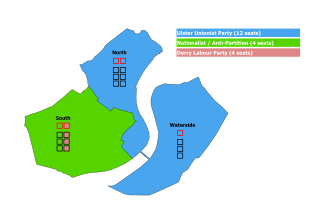
English: Map of results for the 1946 Londonderry Borough Council election. Each ward is coloured according to the party that won the most votes.
Squares represent elected members. Red squares (2 per ward) represent the party affiliation of the elected aldermen. Black squares represent elected councillors (6 in North and South wards, 3 in Waterside). |
| Date | |
| Source | Own work |
| Author | MrPenguin21 |
Licensing
I, the copyright holder of this work, hereby publish it under the following license:
This file is licensed under the Creative Commons Attribution-Share Alike 4.0 International license.
- You are free:
- to share – to copy, distribute and transmit the work
- to remix – to adapt the work
- Under the following conditions:
- attribution – You must give appropriate credit, provide a link to the license, and indicate if changes were made. You may do so in any reasonable manner, but not in any way that suggests the licensor endorses you or your use.
- share alike – If you remix, transform, or build upon the material, you must distribute your contributions under the same or compatible license as the original.
File history
Click on a date/time to view the file as it appeared at that time.
| Date/Time | Thumbnail | Dimensions | User | Comment | |
|---|---|---|---|---|---|
| current | 00:18, 17 November 2020 | | 570 × 366 (114 KB) | MrPenguin21 | Uploaded own work with UploadWizard |
File usage
The following pages on the English Wikipedia use this file (pages on other projects are not listed):
.svg)