
File:Caucasus 1245 AD map de.png
Size of this preview: 771 × 600 pixels. Other resolutions: 309 × 240 pixels | 617 × 480 pixels | 988 × 768 pixels | 1,280 × 995 pixels | 2,560 × 1,991 pixels | 2,995 × 2,329 pixels.
Original file (2,995 × 2,329 pixels, file size: 3.48 MB, MIME type: image/png)
| This is a file from the Wikimedia Commons. Information from its description page there is shown below. Commons is a freely licensed media file repository. You can help. |
Summary
| Description |
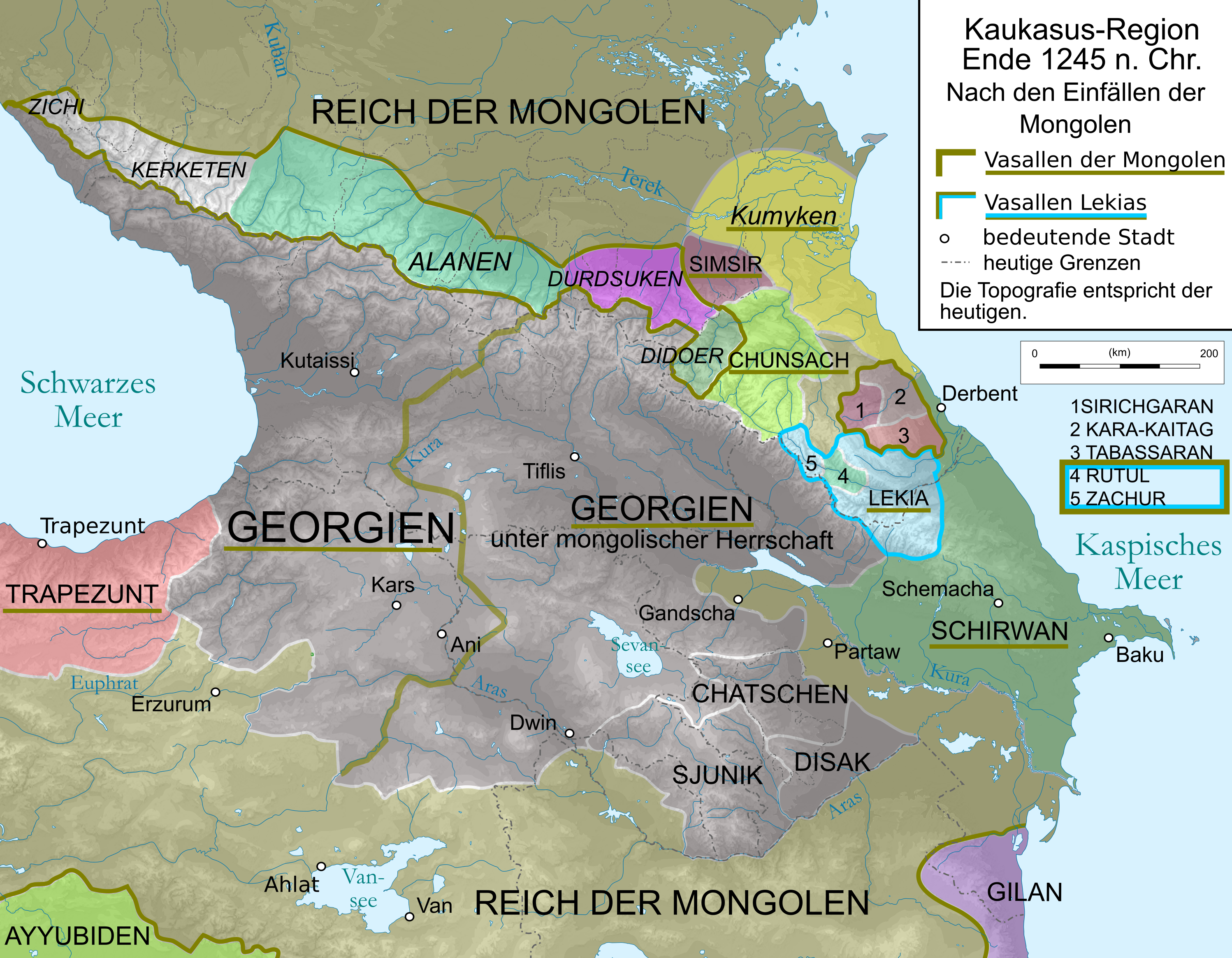
English: Map of Caucasus Region around 1380 in German.
Deutsch: Kaukasus-Region um 1311 n. Chr. Quellen sind: * Michael Kemper: Herrschaft, Recht und Islam in Daghestan. Von den Khanaten und Gemeindebünden zum ǧihād-Staat. Wiesbaden 2005. S. 30–111.
|
| Date | |
| Source | Own work by uploader, derivate of File:Caucasus_topographic_map-fr.svg |
| Author | Don-kun and WajWohu |
| Other versions |
 |
Licensing
I, the copyright holder of this work, hereby publish it under the following licenses:

|
Permission is granted to copy, distribute and/or modify this document under the terms of the GNU Free Documentation License, Version 1.2 or any later version published by the Free Software Foundation; with no Invariant Sections, no Front-Cover Texts, and no Back-Cover Texts. A copy of the license is included in the section entitled GNU Free Documentation License. |
This file is licensed under the Creative Commons Attribution-Share Alike 3.0 Unported, 2.5 Generic, 2.0 Generic and 1.0 Generic license.
- You are free:
- to share – to copy, distribute and transmit the work
- to remix – to adapt the work
- Under the following conditions:
- attribution – You must give appropriate credit, provide a link to the license, and indicate if changes were made. You may do so in any reasonable manner, but not in any way that suggests the licensor endorses you or your use.
- share alike – If you remix, transform, or build upon the material, you must distribute your contributions under the same or compatible license as the original.
You may select the license of your choice.
File history
Click on a date/time to view the file as it appeared at that time.
| Date/Time | Thumbnail | Dimensions | User | Comment | |
|---|---|---|---|---|---|
| current | 19:52, 22 June 2020 | | 2,995 × 2,329 (3.48 MB) | Don-kun | corrections according to discussions, sources will follow |
| 15:20, 6 October 2010 |  | 3,000 × 2,332 (3.53 MB) | Don-kun | {{Information |Description={{en|1=Map of Caucasus Region around 1245 AD in German.}} {{de|1=Kaukasus-Region um 1213 n. Chr. Westlicher Teil Georgiens unter direkter Herrschaft des georgischen Königs als Vasall der Mongolen, östlicher Teil unter mongolis |
File usage
The following pages on the English Wikipedia use this file (pages on other projects are not listed):
Global file usage
The following other wikis use this file:
- Usage on als.wikipedia.org
- Usage on az.wikipedia.org
- Usage on de.wikipedia.org
- Usage on hu.wikipedia.org
- Usage on ka.wikipedia.org
- Usage on lv.wikipedia.org
- Usage on sq.wikipedia.org
- Usage on sr.wikipedia.org
- Usage on tr.wikipedia.org
- Usage on uk.wikipedia.org